Showing posts with label Better Mapping. Show all posts

Friday, 20 December 2013

BCS President’s Monthly Bulletin December 2013


Anniversaries
So we come to the final bulletin of our 50th Anniversary Year and December was obviously a quiet month in 1963! There are very few really ‘mappable’ events from 50 years ago, but one that does lend itself is Kenya’s independence.

As the BBC reported it at the time:

“Jomo Kenyatta is certain to become prime minister after his party, Kenya African Nation Union, won the country's first general election.
Thousands of Kenyans ran through the rain-drenched streets of Nairobi tonight cheering at news of the results.”

At a time when the celebrations for the life of Nelson Mandela have just taken place, there are some poignant echoes from Kenyatta’s speech in which he said that although his government aimed to free itself from British colonialism, it would not try to avenge past injustices.

"We are not to look to the past - racial bitterness, the denial of fundamental rights, the suppression of our culture... Let there be forgiveness," 

Kenya is now the biggest and most advanced economy in east and central Africa but it is still a poor developing country. The important agricultural sector is one of the least developed, employing 75 percent of the workforce. 

Despite western donors' early disillusionment with the government, the economy has seen much expansion, evidenced by strong performance in tourism, higher education and telecommunications.

For an eighteen day period, from 19 Dec 1963 – 5 Jan 1964, the Berlin Wall was opened for the first time, allowing West Berliners to visit family living in East Berlin during the Christmas season. One-day permits were required. In what was a foretaste of things to come, this could be considered a brave move on the part of the authorities at the height of the Cold War.

Under an agreement reached between East and West Berlin, over 170,000 passes were eventually issued to West Berlin citizens. Loudspeakers in East Berlin greeted visitors with the news that they were now in "the capital of the German Democratic Republic," a political division that most West Germans refused to accept. Each visitor was also given a brochure that explained that the wall was built to "protect our borders against the hostile attacks of the imperialists." On the West Berlin side, many newspapers berated the visitors, charging that they were pawns of East German propaganda.

Cartography in the news
Just one article this month. The healthy debate on Sat Navs v Atlases will be going on for some time yet and I came across a well-balanced, short article that manages to come to a nice compromise:

Posted by Louisa Keyworth at BCS Corporate Member, Lovell Johns, it does contain the rather worrying quote, “With geography in schools containing less teaching on map reading, two thirds of under 25s would literally be lost if you asked them to read a map, research has claimed.”
Obviously we need to refocus Restless Earth on UK Road Atlas skills!

Mary Baker Eddy Library Mapparium

I came across this stunning piece of cartographic art via a twitter post and have been amazed by the sheer scale of the Mapparium. This glass globe is located in the Mary BakerEddy Library in Boston, Massachusetts. It is constructed of 608 glass panels based on the 1934 Rand McNally world map. The Rambusch Glass Company artists traced these maps onto 1/4 to 1/2 inch thick glass panels and painted them with a coloured powdered glass mixture. Each panel was then fired in a kiln to fuse the colour to the panel. Construction on the Mapparium began in April 1934 and by January 1935 the glass panels were being produced at a rate of about 50 per week, with production accelerated to complete the entire project for June 1st 1935. Once the panels were completed, they were fitted into the spherical bronze frame forming a 10° by 10° graticule that holds the entire structure together. Finally, 300 light bulbs were installed to illuminate the globe from the outside. The total cost for the project was about $35,000 (about $600K in current terms).

Designed by Boston architect Chester Lindsay Churchill, he called his installation the “Mapparium”. It was an immediate and overwhelming success. Within the first four months, more than 50,000 people had come to experience "being at the centre of the earth".

Despite being on a concave surface, which is the complete opposite of how we normally view a globe, it just looks right. Distances, areas and relative locations are all perfectly maintained and as the eye is always the same distance from the object, it doesn’t encounter the distortions that looking at a normal globe introduce.

The Mapparium was renovated in 1998 when a new light and sound system was installed and the panels were cleaned and repaired. On three occasions in 1939, 1958, and again in 1966, different committees discussed updating the map to reflect the geopolitical changes that had taken place since 1934. In 1966, the estimated cost was $175,000 to create and install new glass panels. It was decided that the Mapparium held much more value as an art object, and the idea of updating it was finally dropped.

It remains the only one of its kind, a truly unique cartographic item. I did muse in my twitter feed that it would be nice to have one on this side of the Atlantic as well. We learnt a lot about the UK glass industry during the Black Country Experience weekend, so if anyone knows of a donor with about £400,000 that they are looking to invest and a building with a space large enough to house it please do let me know!
(images provided by kind permission of the Mary Baker Eddy Library)

Better Mapping
We will be looking at a new format for the Better Mapping Seminars in 2014, based on what we have done before but revamped and refocused on web cartography and designing for multiple media. There will still be an opportunity to look at examples of what works and what doesn’t work and I came across a good example recently of a map that at first glance looks good, but then you start to see problems. I am not going to ‘name and shame', you will have to come along to the seminars to find out. Suffice to say that it was produced by a design company, not a cartographic firm and from their website you do get the impression of a certain lack of understanding.

“Mapping


Maps are a perfect example of the importance of good information design. They are functional items and not like conventional packaging or written instructions. Packaging has to be attractive, in the true sense of the word, and information design must be attractive too, in order to capture the readers’ attention in the first place. However, the primary function of any map is to help the user to plan or find his way.

Producing one that achieves this is no mean feat and it is routinely under-estimated how complex a task it actually is – when done well. Maps can fail in two basic ways: they can of course simply be inaccurate and the outcome becomes obvious, but often only when used; they can also fail when the factual content is sound, but presented poorly. Everything on a map is symbolic and all facts are conveyed by implication alone. Maps are not like written instructions and a high cognitive load is being put on the user.

Different situations require different mapping solutions. A geographical map may be ideal in one context and a straight line diagram better in another. Scale is usually very important and simply making a map bigger or smaller is not what scale is about. Scale is about proportion and content.”

Restless Earth
I am very pleased to confirm that the Great Britain Sasakawa Foundation (GBSF) have approved a grant of £2,500 to support the BCS RestlessEarth programme. This is the second consecutive year that the GBSF have supported us with a financial grant and it enables us to continue to offer the workshops to schools totally free of charge. We are very grateful for their continued support. To find out more about GBSF, please visit their website at www.gbsf.org.uk/.

And Finally…
As we come to the end of our 50th Anniversary Year, I hope that you will agree that it has been an incredibly successful celebration of The Society. We crammed an incredible amount into the last 12 months, have had some very high-profile speakers, run an excellent Symposium, published our 50th Anniversary Book and participated in a wide range of cartographic and geographic events. We have recruited over 100 new members this year and our total membership is now around 700. I would like to thank everyone who has helped to make this year such a resounding success.

Do you read this far? I recently asked on Twitter if anyone new of a good explanation of what differentiates a chart from a map. It was sparked by a book that I am currently reading, from which the following is an extract:

“The stock-in-trade of this old gentleman comprised chronometers, barometers, telescopes, compasses, charts, maps, sextants, quadrants, and specimens of every kind of instrument used in the working of a ship's course, or the keeping of a ship's reckoning, or the prosecuting of a ship's discoveries.”

So my Christmas quiz question is, “What is the name of the ‘old gentleman’ referred to in the extract?” First correct answer e-mailed to the address below wins a £10 voucher of their choice (Book, ITunes, M&S, etc).

Best Wishes for a Very Merry Christmas and a Happy New Year – let’s hope that 2014 proves to be as exciting and inspiring as this year has been.

Pete Jones MBE, CGeog, FRGS
20th December 2013

Twitter: @geomapnut

Saturday, 30 March 2013

BCS President’s Report March 2013

It’s always the way isn’t it, very few cartographic related anniversaries in February and then too many in March.
This month sees the 200th anniversary of the birth of Dr John Snow and for anyone who has attended a Better Mapping seminar, the first map will be very familiar to you as it is used by Giles Darkes as part of his talk illustrating how you can present statistical data using maps.
http://en.wikipedia.org/wiki/John_Snow_(physician)
Although he is better known as one of the founding fathers of modern epidemiology, Dr. John Snow produced this map of the area around the Broad Street pump to illustrate his hypothesis that cholera reproduced in the human body and was spread through contaminated water. This contradicted the prevailing theory that diseases were spread by "miasma" in the air. The September 1854 cholera outbreak was centred in the Soho district, close to Snow's house. Snow mapped the 13 public wells and all the known cholera deaths around Soho, and noted the spatial clustering of cases around one particular water pump. He examined water samples from various wells under a microscope, and confirmed the presence of an unknown bacterium in the Broad Street samples. Despite strong scepticism from the local authorities, he had the pump handle removed from the Broad Street pump and the outbreak quickly subsided. Snow subsequently published a map of the epidemic to support his theory.
In his talk Giles cleverly shows how the results can be ‘manipulated’ depending on how you categorise the data. If the area around the pump is partitioned in different ways, it can seriously skew the data and even suggest that the Broad Street pump is not necessarily the problem. A cautionary tale that is still valid today in reminding us that the aggregation and categorisation of data for portrayal graphically is vitally important to the message that we are trying to convey cartographically. Indeed, some anomalies are worth noting. Although the large workhouse just north of Broad Street housed over 500 paupers, it suffered very few cholera deaths because it had its own well (not shown on the map). The workers at the brewery one block east of the Broad Street pump could drink all the beer they wanted; the fermentation killed the cholera bacteria, and none of the brewery workers contracted cholera. Many of the deaths further away from the Broad Street pump were people who worked at the market on Broad Street and drank from that well.

For anyone wishing to find out more, there is an exhibition at the London School of Hygiene & Tropical Medicine, Keppel Street, London WC1E 7HT entitled ‘Cartographies of Life & Death – John Snow and Disease Mapping’. It opened on 15th March and runs until 17th April. 

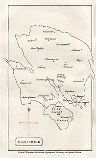
Our second anniversary this month is the 250th anniversary of the birth of William Cobbett, best known for his book Cobbett’s Rides, a topographical narrative of his travels around the south east of England still available in Penguin Classics form. The map I have chosen to illustrate this was published in A Geographical Dictionary of England and Wales, by Cobbett in 1832. The map shows an outline of Hampshire, in an almost unrecognisable shape - either a very strange projection or a bad map! The only features are the main towns.

Cobbett was born in Farnham, Surrey, and his grave can still be seen in the parish churchyard. At various times he was a sergeant-major in the British Army, a campaigning journalist, a political prisoner, an exile in America, the editor of journals, and the Radical MP for Oldham. In the 1820s he returned from political exile in America and undertook a series of rides through the countryside as the basis for a series of articles for publication in his own journal The Political Register. In 1830, he made a selection of the rides and published them in book form. http://www.geog.port.ac.uk/webmap/hantsmap/hantsmap/cobbett/cobbett1.htm         

Coming far more up to date for our third anniversary, this one actually happened 50 years ago when on 27 March 1963 the Chairman of British Railways Dr Richard Beeching issued a report calling for huge cuts to the UK's rail network.The map shows just how extensive our rail network used to be and even this one doesn’t show all the smaller branch lines that criss-crossed the country at the time. The initial report proposed the closure of over 6000 miles of railway and over 2300 stations. Some were reprieved, but over 1900 stations did close and the many ‘dismantled railway’ annotations that appear on OS maps bears testimony to just how many miles of track were decommissioned, with lots of the former lines now forming part of our long distance footpath or national cycle network routes.As one commentator noted, the name ‘Beeching’ quite often evokes a response normally associated with mass murderers and the report was deeply unpopular at the time. The Beeching closures failed in their attempt to eliminate BR's losses, achieving a saving of just £30 million, whilst overall losses were running in excess of £100 million per year. Beeching himself was unrepentant about his role in the closures: "I suppose I'll always be looked upon as the axe man, but it was surgery, not mad chopping." 


What do the following have in common?
  • Maps as music
  • Edwardian transport planning
  • Smells of Paris
  • Pacman
  • The map of 1000 cuts
  • Maps in the media
  • Word maps
They all featured in the Design Group’s excellent one-day workshop entitled ‘How maps inspire us’ at the Steer Davies Gleave offices on 14th March. It really was a fascinating day that took aspects of cartography that we are familiar with but looked at them from a totally different viewpoint.
We were treated to some very engaging talks from a range of speakers and it was noticeable that similar themes kept being picked out. The underlying theme was the sense of place and how we move from being in a ‘space’ to being in a ‘place’ by the things that we associate with it through a variety of senses.. We considered the associative elements of senses and what reminds us most of particular locations – think how often a smell can make you remember a particular place.

Looking ahead:
  • If you haven’t yet booked for the talk by Michael Palin at the RGS on 12th April it’s not too late to do so. Entitled ‘A life in Maps’, it promises to be a fascinating evening from one of our ‘National Treasures’. Book your ticket now
  • BCS will have a panel on the IMIA stand at the London Book Fair from 15th-17th  April, so if you are attending, please make sure that you come and visit us to see the pre-publication details of the BCS 50th anniversary book. Due for publication later this year the book celebrates 50 years of the Society by selecting a UK event and world event from each year and illustrating it with an appropriate map.
    Pre-publication price will be £12.50, so keep an eye on the website in the near future for details.  
Pete Jones MBE, CGeog, FRGS
26th March 2013

Thursday, 9 August 2012

BCS Presidents Report July/August

Dear Members
I thought it would be a good idea to have one report that covered both July and August as, unsurprisingly, we only have one event in August which is the Map Curators meeting in Leeds, 29-30 August. So Map Curators if you haven’t signed up already please do so.

On 13 July I was invited to the British Library for the launch of the Earth Platinum Atlas produced by Millennium House in Australia. It is the largest atlas in the world and just 31 copies will be produced. If you’d like to take a look (or buy one for $1000,000?) check out some images.

On 19 July there was a UK GEOForum meeting in London. The Forum has representatives from 14 associations/societies in geography and mapping industries and is an excellent group facilitating discussions of matters of the moment within the industry and co-operative ventures with organisations like the AGI, RGS and GA.
Indeed, there was a Better Mapping II event in London on 26 July which was organised in co-operation with the AGI and kindly hosted by our ‘initialsakes’, the British Computer Society. No problem with attendees, even just the day before the Olympic Opening Ceremony in London, with all 45 places filled. My thanks must go to our speakers: Peter Jones, Mary Spence, and Clare Seldon. Clare works for Steer Davies Gleave who are very supportive of these events – thank you too.

So after the Map Curators meeting at the end of August, we have a Council meeting on 6 September in London, and we hope to have a stand at the AGI Conference, 19-20 September at The East Midlands Conference Centre in Nottingham.
Then we have our first 2 day Restless Earth Schools Workshop in Penarth, 26-27 September. Looking further ahead still and to give you a ‘heads-up’, the GIS SIG will meet in London on 24 October at our ‘initialsakes’ offices and our AGM/Lecture/Dinner event will be at the RAF Club on 31 October starting at 1700.

Finally, on a personal note, some of you will be aware that I retired from Esri on 30 June after 15 years. I spent my first 5 years working for Esri UK and the remainder for Esri Inc in Redlands. You can’t be President of an organisation such as BCS without the full support of your employer and Esri in Redlands couldn’t have been more helpful. Closer to home, Esri UK are Corporate Members of BCS and sponsors of our Symposium so thank you too.

Let’s hope we have some more sunshine and we can all enjoy the August break.
Best Wishes

Peter Jolly
President of The British Cartographic Society

Wednesday, 4 July 2012

BCS President's Report June 2012

www.facebook.com/bcsweb
The main event in June was, of course, the Symposium held in Basingstoke, well, just outside Basingstoke at the Basingstoke Country Hotel near Hook. The Symposium was preceded by a Restless Earth Schools Workshop and a meeting of the GIS SIG during which presentations were given on the use of GIS by Charities.All-in-all it was indeed a great event, the atmosphere was so friendly and everywhere you looked there were groups of people talking. More importantly it was the third year in succession that the number of attendees had increased by 10% and still more importantly 40% of those who attended were first-timers. Our Corporate members made a great contribution too as 25% of them, 20 in all, took the opportunity to have a stand, twice as many as last year. My thanks once again to our sponsors of the event: Cadcorp, EsriUK, Leica Geosystems, Europa Technologies, Victoria Litho, Star-Apic, Newgrove, Ordnance Survey and Global Mapping. So thank you to all who attended, the speakers and all those involved in the organisation.
On 19 June there was a one day Better Mapping course in Leeds. A week before the event only 11 people had registered for the course and we, BCS and our partners AGI, seriously considered cancelling it. However, ‘we didn’t get where we are today by giving up’ and as happens so often these days there were a number of people who registered late in the day and we had 21 on the course in the end.
The next Better Mapping event will be held in The British Computer Society offices in London on 26 July. All the details are on the BCS website:
http://www.cartography.org.uk/bettermapping
On 21 June the BCS/RGS team were in Northampton delivering a Schools Restless Earth Workshop. There were 2 sessions with 75 students taking part in the morning and 65 in the afternoon. Assuming we do 2 of these Workshops each month during term time as we’ve done this financial year we now have some idea of the annual cost and will be seeking sponsorship in the coming months.
We held a Council meeting on 28 June in London when the main topic was the preparations for 2013, BCS’s 50th Anniversary. We have lots of good ideas, a special book, attendance at the ICC in Dresden, lectures etc. There should be about one event a month. When our plans are firm-up we will, of course, make them easily available. June 30 is our financial year end and it looks as though we will end the year with a small surplus, which is good as we’ll be spending a little more in 2013 on the 50th Anniversary celebrations. We have 606 paid up members this calendar year, so far, which includes 47 new members which is really good news.
Finally, don’t forget nominations for Council have to be submitted by 1 August - 2013 will be a great year to be on the Council.
Best Wishes
President of The British Cartographic Society

Thursday, 31 May 2012

BCS President's Report May 2012

When I was thinking about what I could include in this report my first thought was that not a lot has happened in May but actually it’s been quite busy. BCS was represented at the GEOData event in Dublin on 1 May and this was noteworthy as we are thinking of running a BCS Better Mapping event there later in the year. It could be an important area for attracting new members.
Another successful Restless Earth Schools Workshop was held in Stoke-on-Trent on 9 May and some more of our members, who hadn’t been involved before, took part. We had a stand at the Esri UK one day Conference in London on 15 May and there was another GEOData event in Manchester on 17 of the month and on the 28th  we had a UKCC meeting in London.

Recently I had a week in Redlands at the Esri HQ and Ken Field and Linda Beale very kindly hosted a party so that I could say ‘thank you’ to all my friends there who have helped me over the last 15 years – there are about 6 BCS members over there now. On Tuesday, 29th I’m off to Dresden for the IMTA(EAME) Conference. There’ll be quite a few BCS members there too and, of course, the next ICA Conference is in Dresden in August 2013, our 50th Anniversary year. We hope to share a stand there with Maney’s.

You’ll be interested to know that we are in the initial stages of re-branding BCS which we hope to have completed by the end of the year ready for 2013. Whatever happens it’s bound to be controversial, there’s bound to be lots of ‘huffing and puffing’ but we need to do it to help with our recruiting drive and give BCS a ‘fresh face’.

Our next big event is the BCS Symposium, 13-15 June. There is still time to book your place and I’m delighted to say that the numbers are up on last year. On Wednesday morning there will be a Restless Earth Workshop for schools in the area and the GIS SIG meets that afternoon. Just a further reminder, the exhibition opens at 5pm on Wednesday 13 June with a drinks reception and is followed by a talk from Claire Dobbin, Head Curator of London Transport Museum which promises to be fascinating. A very special ‘thank you’ to our Symposium sponsors for their support: Cadcorp, Esri UK, Leica Geosytems, Europa Technologies, Victoria Litho, Newgrove, Ordnance Survey, Star-Apic and Global Mapping.

After the Symposium there is a Better Mapping event in Leeds on 19 June and a Better Mapping 2 in London on 26 June followed by a BCS Council meeting in London on 28 June. This Council meeting will be preceded as usual by a Programme Committee meeting which this time will be focusing on the 2013 BCS 50th Anniversary events. It’s only 7 months away.

Let’s hope this sunny weather continues.
Best Wishes
President of The British Cartographic Society

Saturday, 19 November 2011

WHY JOIN BCS?

Anyone with an interest in maps can join the British Cartographic Society (BCS). You don’t have to be a cartographer; you don’t have to be a map maker. You may just like maps or be involved in the broader mapping industry or design. After all, cartography is an art and that art can be enjoyed and developed by many. The primary role of the BCS is to promote the art of good cartography.

BCS is a broad church with professionals from academia, government, military, business and all shades between. So, you can join BCS as an individual or it may be that corporate membership is more appropriate. Corporate members get a free stand space at the Society’s annual symposium and can submit articles for publication about their products to the Maplines team who edit the Society’s magazine. Individuals can submit articles too.
   
Maplines is the Society’s magazine and 3 editions are produced each year. The Cartographic Journal has 4 editions a year and is peer reviewed. Consequently it enjoys an international reputation for very high quality articles about all aspects of cartography and is a major source of income for the Society. Cartographiti is the magazine of the Map Curators’ Group (MCG) which usually meets twice a year.

The MCG is just one of 4 Special Interest Groups (SIGs) which are open to Society members and others with a specific interest. The GIS SIG also meets twice a year and concentrates on issues that are of special interest to the expanding GIS community. The Design Group focuses on all aspects of cartographic design, meets twice a year and publishes articles in the Maplines magazine. The Historical Military Mapping Group has a new convener so meetings should resume in the near future.

You cannot promote the art of good cartography without providing some training opportunities. The one day Better Mapping teaching sessions have been running now for over 4 years. First the courses were at a basic level but now there is an advanced course as well. These courses are open to all and take place at various locations around the country several times a year. Attendance at these courses entitles participants to claim CPD points towards Chartered Geographer status or maintain that qualification.


CPD points can also be claimed after participation as a mentor in the BCS Restless Earth programme. The Restless Earth exercises are run for year 10 students at their schools. Presently the scenario is based on the Japanese earthquake, tsunami and nuclear incident around Sendai. Students, in teams of 5, are given maps of the area, access to the internet during the 2 hour exercise and tasked with producing a map that will enable the rescue teams and aid agencies to carry out their various humanitarian tasks. This is a really exciting programme. Not only is it a fun exercise to be involved in but more importantly it demonstrates to the students the essential and incredible value of maps, both hard and soft copy, when it comes to disaster management.

The Society runs a Restless Earth exercise alongside the Annual Symposium which is held in June at a variety of locations around the UK. The Symposium also attracts CPD points, lasts 3 days and there are lectures, workshops, SIG meetings and the corporate members are invited to take part in the exhibition. At the Gala Dinner the awards are presented to the winners in some 8 categories. There is also a golf competition for the Golden Ball trophy.

The British Cartographic Society has a lot to offer the membership and continues to develop new ideas and ways of promoting good cartography within the organisation and beyond.

BCS President’s Report November 2011

It’s been quite a busy time. As planned, the GIS SIG, AGM and award ceremony took place in London at the RAF Club on 1 November. The GIS SIG was a great success with attendees learning how and how not to produce schematic maps – the choice of angles, straight lines or curved lines is all important. Also, included in the programme was a brief on the recent ICC in Paris as it’s important that members know how our involvement with the ICA is working. There is a meeting of ICA chairs of commissions in Vienna about now and I have suggested that there should be regular reports on the work of the commissions published in a journal by the ICA. The AGM went well and after it had been concluded I presented Mike Wilburn with the NewMapmaker award sponsored by National Geographic.

The following day, Council met in London at Prospect House. The sales of ‘Cartography – an introduction’ have been so good that it looks as though we’ll have to do a reprint. The Programme Committee is busy putting together the 2012 programme which at the moment includes 4 Restless Earth events at schools and they are beginning to put together the schedule for our Annual Symposium at the Basingstoke Country Hotel from 13-15 June where the theme will be ‘Mapping the Global Village’. Also, I’m delighted to be able to tell you that Dr John Peaty from DGC has volunteered to take over as the convener of the HMMG – thank you John.  After the Council meeting we had the first meeting of the 2013 committee. As you’ll be aware it’s the 50th anniversary of the foundation of BCS in 2013 so we are planning to have a number of special events to celebrate the occasion. So far we have just an outline in the form of an initial calendar of events which we’ll build upon.

The Restless Earth event at Altrincham Boys GS was a great success so much so that we’ve been asked to go back and run the exercise again next year. We were helped by 5 Royal Geographical Society (RGS) ambassadors who are undergraduates at Manchester University. This worked extremely well for all concerned and I hope we’ll be able to call upon support from other RGS ambassadors at future schools events. In our busy start to November, Steer Davies Gleave also hosted our next Better Mapping Seminar in London run by AGI and BCS. As these seminars continue to be so well attended we plan to run more from Spring 2012.

The next major event is the Mapping Showcase on 1 December at the Emirates Stadium under the LMF banner. The UKCC meets on 10 January. We have a BCS stand at the DGI Show in London 24-25 January and the UK GEOForum Annual Lecture is on 26 January at the RICS when the speaker will be Mike Parker.

At the last Council meeting I undertook to write a page entitled, ‘Why Join BCS’. I have done that and it will appear on this blog also. If there is anything you think I should add please leave me a comment. So far this year we’ve attracted about 85 new members and I’d like to see if we can make it 100!  So, perhaps you can use ‘Why Join BCS’ to make this happen. Anyone who applies for membership now will have membership until 31 December 2012 – an ideal Christmas present for someone?!

Best Wishes
BCS President

Monday, 24 October 2011

BCS President’s Report October 2011

The Restless Earth event at Lampton School on 26 September was a great success. My thanks to all who took part and especially the team from DGC led by Peter Jones. Details of the schools which have attended the programme so far are at: http://www.cartography.org.uk/schools  The next Restless Earth event will be at Altrincham Boys’ Grammar School on Wednesday 16 November. If there is anyone in the area who would like to offer assisitance with this event please do contact us.

The UK GEOForum met on 27 September. Two forthcoming events were highlighted, first the Mapping Showcase on 1 December at the Emirates Stadium under the LMF banner and second the UK GEOForum Annual Lecture on 26 January 2012 at the RICS when the speaker will be Mike Parker.
As President of BCS I was invited to lunch in the House of Lords on 7 October but more about that in the next edition of Maplines.  A number of BCS members attended the Frankfurt Book Fair from 11-16 October and we gained a couple of new members during the Fair.

The next major event and an important event is the luncheon, GIS SIG, BCS AGM and Award ceremony at the RAF Club on 1 November. This promises to be a fascinating afternoon with excellent speakers so if you haven’t already registered for the event then please do so. Also, the results of the elections to Council will be announced and the new Council will meet the following day in Prospect House which is near Waterloo station. I’ll let you know about that meeting in my next report.

Also don't forget the next Better Mapping Seminar on November 8th. For next year’s diary our Annual Symposium will be from 13-15 June at the Basingstoke Country Hotel where the theme will be, ‘Mapping the Global Village’. So there is a lot to look forward to!

Best Wishes
Peter Jolly
BCS President

Blog List