Showing posts with label GIS. Show all posts

Monday, 8 December 2014

BCS President's Bulletin November 2014


The BCS AGM was held at the RAF Club in London on 17th November and we reflected on another successful year for the Society. The Restless Earth schools' programme is proving to be as popular as ever, the Annual Symposium at Marwell ran jointly with IMIA was a great success, the BCS Awards were rejuvenated and proved to be a highlight of the Gala Dinner and our membership continues to grow, topping 700 at the end of the month. We are also in very good health financially and in response to a question at the AGM the Council will be looking at the reserves that we hold and will be determining ways of investing and using our assets to further develop the Society. We are aware that the BCS website needs updating and we will be offering online access to the Cartographic Journal in 2015, but if you have any specific proposals for how BCS funds could be employed then please get in touch.

The AGM was followed by a talk by BBC weather presenter Helen Willetts, who spoke about the ‘Changing Face of the Weather Map’. It was an excellent talk during which Helen covered a far greater timespan that I had anticipated, from ancient times right up to the modern day. It was a really entertaining and informative talk, sparked many questions from the audience and finally solved the mystery for me of the seven legged spider. Helen confessed afterwards that she hadn’t spoken in public for nearly eight years, but you couldn’t tell and she also confided to me that she had thoroughly enjoyed the evening.

Cartography in the News

You know you’re in trouble when the reigning monarch says that maps have been overtaken by satnavs, although if you read the article the headline is a bit misleading and that’s not what she actually said. What she actually said to one of the pupils who was finding co-ordinates on a map is that ‘Nowadays you probably have a satnav or something’. Yes, Ma'am, that something is a map. On the same page in the paper was a report on proposed changes to the driving test including 'asking candidates to follow directions on a satnav, as an alternative to following road signs'. I’m sorry but isn’t that just plain daft? I never navigate simply by following road signs, if I did getting from my home in Woking to say Leeds could be a bit of a challenge if I was relying solely on road signs as there aren’t too many in Woking that tell you where Leeds is. Edmund King president of the AA chimed in with 'Some still navigate with signs and maps'; useful concept ‘some’ just imprecise enough not to be able to disagree with it too vehemently.

Cartography on the Web

Just to remind us all that paper maps and satnavs are not necessarily mutually exclusive, a web article from HEMA maps, ‘down under’, shows how the two can be used successfully together. Rob Boegheim, the company’s managing director always starts his planning process with a paper map as he argues that its scope is still the best way to get the big picture when planning a trip. The progression from planning at home to discovering somewhere out in the bush, instantly transforms the basic paper map from planning tool into cheap insurance. Though the likelihood of technological failure is rare in most cases, a paper map is always an essential low cost backup that will pay dividends when called upon on the expedition.


Apparently brains and cauliflowers are similar in size and shape but if you have ever wondered what a map of your brain would look like, then we now have the answer. Nico Lambert’s rendering can be found at the link.


One of the guest speakers from our 50th Anniversary year, Jack Dangermond, has recently been quoted as saying that he wants top executives to think more like cartographers. Growth of GIS beyond its original boundaries is now making people realise the benefits to analysis and decision making if the geospatial element is fully considered. What is broadly termed as ‘location strategy’ is now a large factor in business allowing those who employ it to gain the competitive advantage.

I have been showcasing the ICA Map Carte webpage for the whole year (see below) and a new article by ICA President Georg Gartner, looks at cartography in the 21st century. One of his key points echoes the thoughts of HEMA maps in that there are significant differences in the way we use paper and digital outputs. Using a paper map gives you the broader picture so that you quickly develop a sense of place and can navigate an area comfortably relatively quickly, whereas the convenience of a small screen makes you concentrate on directions without developing that same sense of your surroundings.


The BCS Better Mapping seminars offered the concept that as well as literacy and numeracy, there was a third important skill of ‘graphicacy’, ie. the ability to read and understand graphical images, particularly maps. This point is taken up by Kenneth D. Madsen an assistant professor of geography at The Ohio State University at Newark. Whilst not advocating that we all learn by rote the locations of world countries and their capitals, he does argue that just as use of a calculator does not diminish the need to know basic maths and just as knowing the alphabet is a prerequisite for reading, so it is that knowledge of where to find places is useful for a greater understanding of geographic processes.


We have been bombarded over the years with news that cartography is a dying profession and there aren’t any cartographers any more, yet here we are still going very string. Well, now it would appear that GIS professionals are under threat. I subscribe to GISCafe and a recent article talked about a new breed of Geographer or is it Geospatial practitioner, geospatial developer or location specialist. The author Joseph Berry argues that in getting GIS more widely accepted and used amongst a non-specialist community, “We need individuals, who understand the challenges faced by the wider ‘non-GIS’ community. Who can bridge the divide, and communicate spatial solutions to a new set of problems, targeted at a new diverse group of users.” I think we call them cartographers don’t we?

ICA Map Carte

My first choice this month is really easy, Roy’s map of the Hounslow Heath baseline. Easy because his was the predecessor of the organisation that I now work for. Tracing its history back to 1747, Military Survey (as it was once known) mapped the UK and Ireland to a phenomenal degree given the technology at their disposal. You can still see the ends of the baseline marked by two upturned cannons, one in Ordnance Close and one at Heathrow airport, although the vast majority of people probably don’t know what they signify.

Another place on my bucket list is the Vatican, if only to see The Gallery of Maps, a 120m long gallery beautifully decorated with more than 40 works of art. Dating from the 1580s, their vibrant colours and remarkable detail are from an age when maps where starting to assume an important role in scientific discovery. Celebrating the central importance of Italy before it was a unified country, they were commissioned by Pope Gregory XIII, who wanted the Vatican to be a part of the scientific and cartographic revolution of the day.

My final choice this month is not necessarily the most obvious as it is neither beautiful nor particularly eye-catching. The Sachsenhausen Memorial and Museum Visitor Map is very powerful, presenting as the web site describes it 'a poignant and eerily clinical blend…a cold soulless landscape', something which perhaps a photograph could also invoke but something that this map achieves with stunning simplicity.

These and all the other maps that have been chosen throughout the year can be found at http://mapdesign.icaci.org/category/mapcarte/.

And Finally

Well, following last month’s toilet humour picture, for which I got no printable suggestions about what unconventional toilet paper could be, I am really struggling for something to finish this month’s offering. So what I will say is that December’s offering will come out on or about Christmas Eve and will contain exciting news about next year’s Symposium, so think of the next couple of weeks as a kind of BCS Advent Calendar, but without the chocolate.

Pete Jones MBE FBCart.S CGeog
8th December 2014

E-mail: peter.jones991@mod.uk
Twitter: @geomapnut

Thursday, 3 January 2013

BCS President’s Report November 2012


Dear Members and Fellows,

This is my first monthly bulletin to you as your new President. Peter Jolly started the monthly report and I certainly valued it as a way of keeping in touch with what was going on within the Society and so I intend to continue in this tradition with a few little tweaks of my own.

For those of you who may be relatively new to the Society, or whom I have yet to meet at one of our many functions, I thought you might like to know a little more about me. I have worked for the Ministry of Defence for over 30 years and when I started my career in 1979 I said that when I became fed up with working with maps I would then know that it was time to move on. Well, I am still here and not in the least fed up! Maps have always fascinated me and I can remember at primary school when the class was told they could choose their favourite book for "quiet time" I always reached for an atlas. I have been involved with BCS since 1999 and I have spent the last 4 years as Chair of the Programme Committee. I come to the role of President with a sound grounding in both the Society and its Activities.

Our schools' initiative, "Restless Earth", which began in 2011 following on from a discussion of how best to take mapping out to schools, supports the current geography curriculum and is a very popular workshop for GCSE students. In November we delivered 2 workshops in 3 days, in Altrincham and Fleet and there are a further 6 planned for the remainder of the Academic Year.
http://www.gbsf.org.uk
I am pleased to announce that one of my final achievements as Programme Chair was to secure sponsorship from the Great Britain Sasakawa Foundation which was established as a result of a visit to London in 1983 by the late Ryoichi Sasakawa. The purpose of his visit was to meet a number of senior British figures to discuss the international situation and, in particular, UK - Japanese relations. 
It was agreed that it would be in the interest of both countries if more could be done to enhance mutual appreciation and understanding of each other's culture, society and achievements. We are delighted to have the Foundation as our prime sponsor for Restless Earth and look forward to working with them in the future.

A recent noteworthy item in the press has been the controversy over Sandy Island. Shown on Google Maps and nautical maps (sic) – I am sure you could hear the hydrographers shouting at the radio report "They're charts, not maps!" – it has been discovered, or rather not discovered, that it doesn't actually exist! Initially it was thought that perhaps it was simply a digitisation error, but it has since been identified on a 1908 chart in an Auckland museum. It has been reported that the island was the result of an error recorded in 1876 by the crew of the Velocity, a whaling ship, who reported a series of "heavy breakers" and some "sandy islets". This highlights the fact that you cannot always believe what you see on a map or a chart!

Sandy Island
This cartographic controversy also emphasises the point that I have made at several events, that cartography is as important now as it has ever been, if not more so in this era of Geographic Information Systems where software packages, designed by IT specialists, freely available on the internet, "make" your map for you with not a cartographic consideration or principle in sight, which can result in very poor quality products that betray the true essence of a good map. The Society needs to ensure that we reinforce the message that good design and presentation will significantly enhance a cartographic product and that bad design can often cast doubt on a perfectly accurate product that simply does not inspire confidence. Of course, the reverse is equally true, but that is another story!

Finally, I would like to take this opportunity in my first President's Bulletin to thank Peter Jolly for his Presidency over the past 2 years. During that time our membership has continued to grow, which is no mean feat in this current climate. He has handed over a flourishing Society and I look forward to all the events planned for our 50th Anniversary in 2013. In advance, I encourage you all to attend as many events as you can as it promises to be a memorable year for The British Cartographic Society.

Best wishes,

Wednesday, 22 August 2012

GIS special interest group report

This year’s GIS SIG at the Symposium discussed the use of GIS in the charity and not-for-profit sector.  Map Action, Birdlife, The RNLI and Global Map Aid each spent 30 minutes discussing their work and how GIS is helping to create business insight. 

GIS is helping to save and conserve lives, both human and animal around the world on both land and at sea.  With the current economic unrest donations to charitable organisations are falling.  Every pound spent is increasingly important.  GIS analysis combined with strong cartographic outputs enables charities to better understand their operational environment and how to focus spend appropriately. Using GIS charities are able to make better informed decisions on where to invest donations in the most appropriate way and importantly justify their activities to the communities which support them. 

I’d like to thank Ming Lee from MapAction, Mark Balman of Birdlife, Dan Ryan from RNLI and Doug Eamer from Global Map Aid for taking the time to speak at the SIG.  The volume of questions at the end of the presentations highlighted another successful session.

If any members of the society would like to suggest topics for future GIS SIGs or would like to present please drop Rob Sharpe a line at: rsharpe@esriuk.com 
Rob Sharpe
--
note from author:
The BCS would also like to congratulate Ming Lee from MapAction on his Olympic Torch bearing duty in London in the final stages of the relay where he handed the flame over to Prince Harry after being invited to fly the flag for volunteering.
http://www.hellomagazine.com/royalty/201207278803/olympic-flag-arrives-in-london/

Thursday, 9 August 2012

BCS Presidents Report July/August

Dear Members
I thought it would be a good idea to have one report that covered both July and August as, unsurprisingly, we only have one event in August which is the Map Curators meeting in Leeds, 29-30 August. So Map Curators if you haven’t signed up already please do so.

On 13 July I was invited to the British Library for the launch of the Earth Platinum Atlas produced by Millennium House in Australia. It is the largest atlas in the world and just 31 copies will be produced. If you’d like to take a look (or buy one for $1000,000?) check out some images.

On 19 July there was a UK GEOForum meeting in London. The Forum has representatives from 14 associations/societies in geography and mapping industries and is an excellent group facilitating discussions of matters of the moment within the industry and co-operative ventures with organisations like the AGI, RGS and GA.
Indeed, there was a Better Mapping II event in London on 26 July which was organised in co-operation with the AGI and kindly hosted by our ‘initialsakes’, the British Computer Society. No problem with attendees, even just the day before the Olympic Opening Ceremony in London, with all 45 places filled. My thanks must go to our speakers: Peter Jones, Mary Spence, and Clare Seldon. Clare works for Steer Davies Gleave who are very supportive of these events – thank you too.

So after the Map Curators meeting at the end of August, we have a Council meeting on 6 September in London, and we hope to have a stand at the AGI Conference, 19-20 September at The East Midlands Conference Centre in Nottingham.
Then we have our first 2 day Restless Earth Schools Workshop in Penarth, 26-27 September. Looking further ahead still and to give you a ‘heads-up’, the GIS SIG will meet in London on 24 October at our ‘initialsakes’ offices and our AGM/Lecture/Dinner event will be at the RAF Club on 31 October starting at 1700.

Finally, on a personal note, some of you will be aware that I retired from Esri on 30 June after 15 years. I spent my first 5 years working for Esri UK and the remainder for Esri Inc in Redlands. You can’t be President of an organisation such as BCS without the full support of your employer and Esri in Redlands couldn’t have been more helpful. Closer to home, Esri UK are Corporate Members of BCS and sponsors of our Symposium so thank you too.

Let’s hope we have some more sunshine and we can all enjoy the August break.
Best Wishes

Peter Jolly
President of The British Cartographic Society

Wednesday, 4 July 2012

BCS President's Report June 2012

www.facebook.com/bcsweb
The main event in June was, of course, the Symposium held in Basingstoke, well, just outside Basingstoke at the Basingstoke Country Hotel near Hook. The Symposium was preceded by a Restless Earth Schools Workshop and a meeting of the GIS SIG during which presentations were given on the use of GIS by Charities.All-in-all it was indeed a great event, the atmosphere was so friendly and everywhere you looked there were groups of people talking. More importantly it was the third year in succession that the number of attendees had increased by 10% and still more importantly 40% of those who attended were first-timers. Our Corporate members made a great contribution too as 25% of them, 20 in all, took the opportunity to have a stand, twice as many as last year. My thanks once again to our sponsors of the event: Cadcorp, EsriUK, Leica Geosystems, Europa Technologies, Victoria Litho, Star-Apic, Newgrove, Ordnance Survey and Global Mapping. So thank you to all who attended, the speakers and all those involved in the organisation.
On 19 June there was a one day Better Mapping course in Leeds. A week before the event only 11 people had registered for the course and we, BCS and our partners AGI, seriously considered cancelling it. However, ‘we didn’t get where we are today by giving up’ and as happens so often these days there were a number of people who registered late in the day and we had 21 on the course in the end.
The next Better Mapping event will be held in The British Computer Society offices in London on 26 July. All the details are on the BCS website:
http://www.cartography.org.uk/bettermapping
On 21 June the BCS/RGS team were in Northampton delivering a Schools Restless Earth Workshop. There were 2 sessions with 75 students taking part in the morning and 65 in the afternoon. Assuming we do 2 of these Workshops each month during term time as we’ve done this financial year we now have some idea of the annual cost and will be seeking sponsorship in the coming months.
We held a Council meeting on 28 June in London when the main topic was the preparations for 2013, BCS’s 50th Anniversary. We have lots of good ideas, a special book, attendance at the ICC in Dresden, lectures etc. There should be about one event a month. When our plans are firm-up we will, of course, make them easily available. June 30 is our financial year end and it looks as though we will end the year with a small surplus, which is good as we’ll be spending a little more in 2013 on the 50th Anniversary celebrations. We have 606 paid up members this calendar year, so far, which includes 47 new members which is really good news.
Finally, don’t forget nominations for Council have to be submitted by 1 August - 2013 will be a great year to be on the Council.
Best Wishes
President of The British Cartographic Society

Thursday, 31 May 2012

BCS President's Report May 2012

When I was thinking about what I could include in this report my first thought was that not a lot has happened in May but actually it’s been quite busy. BCS was represented at the GEOData event in Dublin on 1 May and this was noteworthy as we are thinking of running a BCS Better Mapping event there later in the year. It could be an important area for attracting new members.
Another successful Restless Earth Schools Workshop was held in Stoke-on-Trent on 9 May and some more of our members, who hadn’t been involved before, took part. We had a stand at the Esri UK one day Conference in London on 15 May and there was another GEOData event in Manchester on 17 of the month and on the 28th  we had a UKCC meeting in London.

Recently I had a week in Redlands at the Esri HQ and Ken Field and Linda Beale very kindly hosted a party so that I could say ‘thank you’ to all my friends there who have helped me over the last 15 years – there are about 6 BCS members over there now. On Tuesday, 29th I’m off to Dresden for the IMTA(EAME) Conference. There’ll be quite a few BCS members there too and, of course, the next ICA Conference is in Dresden in August 2013, our 50th Anniversary year. We hope to share a stand there with Maney’s.

You’ll be interested to know that we are in the initial stages of re-branding BCS which we hope to have completed by the end of the year ready for 2013. Whatever happens it’s bound to be controversial, there’s bound to be lots of ‘huffing and puffing’ but we need to do it to help with our recruiting drive and give BCS a ‘fresh face’.

Our next big event is the BCS Symposium, 13-15 June. There is still time to book your place and I’m delighted to say that the numbers are up on last year. On Wednesday morning there will be a Restless Earth Workshop for schools in the area and the GIS SIG meets that afternoon. Just a further reminder, the exhibition opens at 5pm on Wednesday 13 June with a drinks reception and is followed by a talk from Claire Dobbin, Head Curator of London Transport Museum which promises to be fascinating. A very special ‘thank you’ to our Symposium sponsors for their support: Cadcorp, Esri UK, Leica Geosytems, Europa Technologies, Victoria Litho, Newgrove, Ordnance Survey, Star-Apic and Global Mapping.

After the Symposium there is a Better Mapping event in Leeds on 19 June and a Better Mapping 2 in London on 26 June followed by a BCS Council meeting in London on 28 June. This Council meeting will be preceded as usual by a Programme Committee meeting which this time will be focusing on the 2013 BCS 50th Anniversary events. It’s only 7 months away.

Let’s hope this sunny weather continues.
Best Wishes
President of The British Cartographic Society

Monday, 12 March 2012

Guest Blog: From Kirkbie, Kendal to Sendai, Japan

Restless Earth Geography Workshop at Kirkbie Kendal School – Tuesday 21st February

On a dark, wet and wild morning the British Cartographic Society blew into Kirkbie Kendal School, Kendal. The recently broadcast drought in the Southeast of England seemed a distant memory as Cumbria delivered its famous rain!

During the Restless Earth workshop our GCSE pupils participated in a hazard mapping task based on the Japanese Tsunami 2011. They were able to work in groups each taking on a specific roles within the team; Humanitarian; Military; Search and rescue; Medical; Co-Ordinator roles.
The challenge was to use the maps to produce two hazard maps that would show where helicopters could land, where supplies could be delivered, which roads were accessible, the implication of the Fukushima nuclear power plant exclusion zone and where survivors could be taken.

The Restless Earth workshop enabled our pupils to actively engage with maps and use them for a purpose. It was inspirational to see our mixed ability pupils all engaging with contemporary content and exhibit a real sense of curiosity.

The current Ofsted Geography criteria states that an outstanding department must make , “…very effective use is made of ICT and Geographical Information Systems (where relevant) to promote learning and enable pupils to use data and information sources to search and select, organise and investigate and refine and present information skilfully and independently.” (www.ofsted.gov.uk , Jan 2012).

In the past this has often been difficult to meaningfully implement; the expensive nature of the software packages, difficultly accessing ICT in schools and linking it to the curriculum in a cohesive fashion rather than tacked on are often limiting factors. The BCS workshop allows departments deliver this element successfully.

The way in which the BCS workshop was planned and delivered allowed all our pupils to gain skills and in many cases has been a highlight of this academic year for pupils and staff. Pupil feedback included; “You can think about if you were in that situation what you would do. It also helps you take on a revision but in a different way.”
“I enjoyed solving the problem (e.g. where would the hospital go?) but it did get a little confusing as there were so many things to take in to consideration!!”
“I enjoyed learning more about maps and practising map skills. I also liked the way everyone had their own task to complete.”
“The teamwork, I really enjoyed looking at maps and feeling like we were actually planning it all.” Although we did have one pupil comment that it would have helped if the maps of Japan had not been in Japanese!

It was delightful to see different geography communities collide – the sharing of skills from the British Cartographic Society, the support of the Geographical Association ambassadors, Geography teachers being supported in embedding skills and the opportunity to see pupils engage with new concepts. It was genuinely an exciting experience and we hope that collaborations such as this continue to be an area supported by the BCS and the GA.

Fiona Derbyshire, Head of Geography, Kirkbie Kendal School

Find out more about The BCS Resltess Earth Workshops http://www.cartography.org.uk/schools

Friday, 25 November 2011

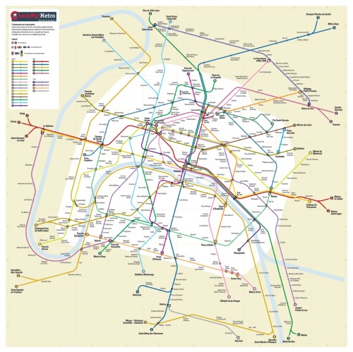
Guest Blog - Paris Metro Map design

In the light of the discussions at the recent GIS SIG seminar, I thought BCS members may be interested in a competition to create a new Paris Metro map. 
I was invited to take part and have been selected as one of the finalists. The overall winner will be selected by popular vote (via Facebook) but I’m not asking for mine to be favoured, I just thought the competition needs as wide an audience as possible. I have the impression it is the sort of thing that may interest the members of the BCS and ICA especially as the last meeting was in Paris.

I would be interested to hear what you and the other members think of the entries:
See the facebook page

And here is the link to the press release: http://checkmylabs.tumblr.com/

Mark,
Mark Noad Design

Saturday, 19 November 2011

BCS President’s Report November 2011

It’s been quite a busy time. As planned, the GIS SIG, AGM and award ceremony took place in London at the RAF Club on 1 November. The GIS SIG was a great success with attendees learning how and how not to produce schematic maps – the choice of angles, straight lines or curved lines is all important. Also, included in the programme was a brief on the recent ICC in Paris as it’s important that members know how our involvement with the ICA is working. There is a meeting of ICA chairs of commissions in Vienna about now and I have suggested that there should be regular reports on the work of the commissions published in a journal by the ICA. The AGM went well and after it had been concluded I presented Mike Wilburn with the NewMapmaker award sponsored by National Geographic.

The following day, Council met in London at Prospect House. The sales of ‘Cartography – an introduction’ have been so good that it looks as though we’ll have to do a reprint. The Programme Committee is busy putting together the 2012 programme which at the moment includes 4 Restless Earth events at schools and they are beginning to put together the schedule for our Annual Symposium at the Basingstoke Country Hotel from 13-15 June where the theme will be ‘Mapping the Global Village’. Also, I’m delighted to be able to tell you that Dr John Peaty from DGC has volunteered to take over as the convener of the HMMG – thank you John.  After the Council meeting we had the first meeting of the 2013 committee. As you’ll be aware it’s the 50th anniversary of the foundation of BCS in 2013 so we are planning to have a number of special events to celebrate the occasion. So far we have just an outline in the form of an initial calendar of events which we’ll build upon.

The Restless Earth event at Altrincham Boys GS was a great success so much so that we’ve been asked to go back and run the exercise again next year. We were helped by 5 Royal Geographical Society (RGS) ambassadors who are undergraduates at Manchester University. This worked extremely well for all concerned and I hope we’ll be able to call upon support from other RGS ambassadors at future schools events. In our busy start to November, Steer Davies Gleave also hosted our next Better Mapping Seminar in London run by AGI and BCS. As these seminars continue to be so well attended we plan to run more from Spring 2012.

The next major event is the Mapping Showcase on 1 December at the Emirates Stadium under the LMF banner. The UKCC meets on 10 January. We have a BCS stand at the DGI Show in London 24-25 January and the UK GEOForum Annual Lecture is on 26 January at the RICS when the speaker will be Mike Parker.

At the last Council meeting I undertook to write a page entitled, ‘Why Join BCS’. I have done that and it will appear on this blog also. If there is anything you think I should add please leave me a comment. So far this year we’ve attracted about 85 new members and I’d like to see if we can make it 100!  So, perhaps you can use ‘Why Join BCS’ to make this happen. Anyone who applies for membership now will have membership until 31 December 2012 – an ideal Christmas present for someone?!

Best Wishes
BCS President

Monday, 24 October 2011

BCS President’s Report October 2011

The Restless Earth event at Lampton School on 26 September was a great success. My thanks to all who took part and especially the team from DGC led by Peter Jones. Details of the schools which have attended the programme so far are at: http://www.cartography.org.uk/schools  The next Restless Earth event will be at Altrincham Boys’ Grammar School on Wednesday 16 November. If there is anyone in the area who would like to offer assisitance with this event please do contact us.

The UK GEOForum met on 27 September. Two forthcoming events were highlighted, first the Mapping Showcase on 1 December at the Emirates Stadium under the LMF banner and second the UK GEOForum Annual Lecture on 26 January 2012 at the RICS when the speaker will be Mike Parker.
As President of BCS I was invited to lunch in the House of Lords on 7 October but more about that in the next edition of Maplines.  A number of BCS members attended the Frankfurt Book Fair from 11-16 October and we gained a couple of new members during the Fair.

The next major event and an important event is the luncheon, GIS SIG, BCS AGM and Award ceremony at the RAF Club on 1 November. This promises to be a fascinating afternoon with excellent speakers so if you haven’t already registered for the event then please do so. Also, the results of the elections to Council will be announced and the new Council will meet the following day in Prospect House which is near Waterloo station. I’ll let you know about that meeting in my next report.

Also don't forget the next Better Mapping Seminar on November 8th. For next year’s diary our Annual Symposium will be from 13-15 June at the Basingstoke Country Hotel where the theme will be, ‘Mapping the Global Village’. So there is a lot to look forward to!

Best Wishes
Peter Jolly
BCS President

Wednesday, 21 September 2011

BCS President’s Report September 2011

As is usual September began with a flourish. 


The UKCC met in York on Monday 5 September. The main topics raised were: first, the ICC in Paris - David Forrest gave a report on the work of the General Assembly and all had an opportunity to comment on the organisation of the event.  The UK won 2 awards, Best Thematic Map – Ken Field and Best Educational Cartographic Product (Digital) – HarperCollins. Second, there were reports from Commission chairs and vice-chairs and lastly, there was an initial discussion on the UKCC Review. A draft paper has been circulated to Council for comment by 30 September prior to a second draft. In future, details of the UKCC’s work and ICA events, commission reports etc will be posted on the BCS website for all to see. Work on this has already begun.


The following day the Council also met at the same venue. This was a routine meeting covering membership and finance, the UKCC Review, Committee and SIG reports. There was also a discussion about having a lunchtime event for Fellows in the spring next year and that discussion is on-going.
On Wednesday the Map Curator’s Group met and I understand had a very successful meeting. My thanks go to Ann Sutherland, April Carlucci, Anne Taylor and Paula Williams for running and organising the event.

We, BCS, have a stand at the AGI Geocommunity ’11 conference in Nottingham 21-22 September. This will be another opportunity to encourage attendees to join BCS. Over the last 12 months membership has increased significantly, up to 657 compared with 615 at the same time last year and, as a result, in part, the financial position of the Society has strengthened. As well as new members from the UK we have new members from Chile, Nigeria, USA and Australia.

FREE attendance for Year 10s
On Monday, 26 September, the BCS team led by Peter Jones, will be presenting the ‘Restless Earth’ package to the year 10 students at Lampton School, Hounslow, in the morning and about 70 students from other schools in the area in the afternoon. It should be a great day.

The following day the UK GEOForum meets at Canary Wharf to discuss matters of mutual interest to the 15 member societies. These meetings are always useful as we can discuss and debate the common concerns.

Next, the cut-off date for submission of articles for the Winter edition of Maplines is 13 October so please make sure that if you have a contribution to make that Lynda Bailey and her team get the information and photographs etc on time. I should also tell you that Martin Lubikowski has taken over as the chairman of the Publications Committee. Our thanks go to Peter Collier for the work he did as Martin’s predecessor.

November 1 is an important date for your diary. There will be a curry lunch in the RAF Club followed by the GIS SIG. The SIG is open to everyone and is entitled, ‘GIS and Schematic Mapping’. These maps are particularly popular in the transport industry and at the end of the sessions we should know more about their uses, advantages and limitations so please do come and join in. There will also be a report of the recent ICC in Paris by David Forrest which again should be of interest to all. Then it will be time for the AGM at which the election results for Council for the coming year will be announced. Roger Hore will be sending out all the necessary paper work shortly. All booking details are on the BCS website.

So, a busy time for all but very worthwhile.
Best Wishes
Peter Jolly
BCS President

Blog List