Showing posts with label maps. Show all posts

Thursday, 3 January 2013

BCS President’s Report November 2012


Dear Members and Fellows,

This is my first monthly bulletin to you as your new President. Peter Jolly started the monthly report and I certainly valued it as a way of keeping in touch with what was going on within the Society and so I intend to continue in this tradition with a few little tweaks of my own.

For those of you who may be relatively new to the Society, or whom I have yet to meet at one of our many functions, I thought you might like to know a little more about me. I have worked for the Ministry of Defence for over 30 years and when I started my career in 1979 I said that when I became fed up with working with maps I would then know that it was time to move on. Well, I am still here and not in the least fed up! Maps have always fascinated me and I can remember at primary school when the class was told they could choose their favourite book for "quiet time" I always reached for an atlas. I have been involved with BCS since 1999 and I have spent the last 4 years as Chair of the Programme Committee. I come to the role of President with a sound grounding in both the Society and its Activities.

Our schools' initiative, "Restless Earth", which began in 2011 following on from a discussion of how best to take mapping out to schools, supports the current geography curriculum and is a very popular workshop for GCSE students. In November we delivered 2 workshops in 3 days, in Altrincham and Fleet and there are a further 6 planned for the remainder of the Academic Year.

http://www.gbsf.org.uk
I am pleased to announce that one of my final achievements as Programme Chair was to secure sponsorship from the Great Britain Sasakawa Foundation which was established as a result of a visit to London in 1983 by the late Ryoichi Sasakawa. The purpose of his visit was to meet a number of senior British figures to discuss the international situation and, in particular, UK - Japanese relations. 
It was agreed that it would be in the interest of both countries if more could be done to enhance mutual appreciation and understanding of each other's culture, society and achievements. We are delighted to have the Foundation as our prime sponsor for Restless Earth and look forward to working with them in the future.

A recent noteworthy item in the press has been the controversy over Sandy Island. Shown on Google Maps and nautical maps (sic) – I am sure you could hear the hydrographers shouting at the radio report "They're charts, not maps!" – it has been discovered, or rather not discovered, that it doesn't actually exist! Initially it was thought that perhaps it was simply a digitisation error, but it has since been identified on a 1908 chart in an Auckland museum. It has been reported that the island was the result of an error recorded in 1876 by the crew of the Velocity, a whaling ship, who reported a series of "heavy breakers" and some "sandy islets". This highlights the fact that you cannot always believe what you see on a map or a chart!

Sandy Island
This cartographic controversy also emphasises the point that I have made at several events, that cartography is as important now as it has ever been, if not more so in this era of Geographic Information Systems where software packages, designed by IT specialists, freely available on the internet, "make" your map for you with not a cartographic consideration or principle in sight, which can result in very poor quality products that betray the true essence of a good map. The Society needs to ensure that we reinforce the message that good design and presentation will significantly enhance a cartographic product and that bad design can often cast doubt on a perfectly accurate product that simply does not inspire confidence. Of course, the reverse is equally true, but that is another story!

Finally, I would like to take this opportunity in my first President's Bulletin to thank Peter Jolly for his Presidency over the past 2 years. During that time our membership has continued to grow, which is no mean feat in this current climate. He has handed over a flourishing Society and I look forward to all the events planned for our 50th Anniversary in 2013. In advance, I encourage you all to attend as many events as you can as it promises to be a memorable year for The British Cartographic Society.

Best wishes,

Thursday, 31 May 2012

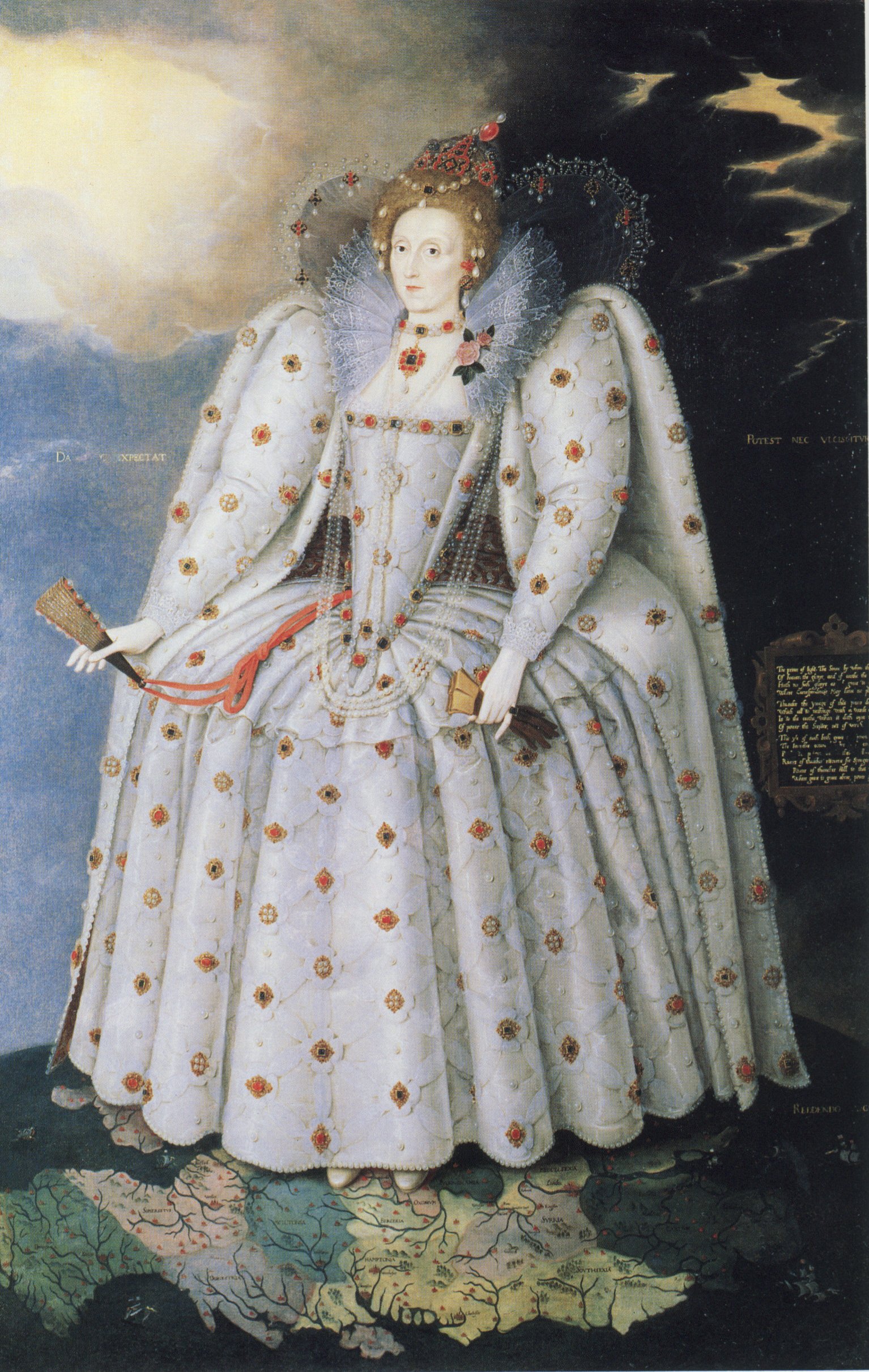
Queen Elizabeth I Minds the Map...


Art work by BCS Member Peter Vujakovic, for our Maplines Magazine, has been chosen for inclusion in the London Transport Museum’s (LTM) major Summer Exhibition. The exhibition about the history and creativity behind London transport maps opened on Friday 18 May 2012 and continues until 28 October. Mind the Map: inspiring art, design and cartography draws on the Museum’s art work and map collection to explore the themes of journeys, identity and publicity. The exhibition includes previously unseen historic material and exciting new work by leading artists. Over 20,000 people will read about Maplines Magazine and The British Cartographic Society as they pass through the exhibition this summer.
Peter’s cartoon satirises the attempt by Transport for London to remove the Thames from the iconic tube map in 2009. The cartoon shows Queen Elizabeth I astride the tube map indicating her displeasure at its removal and requiring that it is replaced before she takes the Royal Barge to town. The cartoon originally featured in the Winter 2009 issue of Maplines, the magazine of the British Cartographic Society. Peter is Professor of Geographical and Life Sciences at Canterbury Christ Church University, a member of the society and is a co-convenor of its Map Design Special Interest Group. See past editions of Maplines to see Peter's view of how other great minds of the past might grapple with the big issues of today!.
It is interesting to consider that this image is on display in the Jubilee year in which Elizabeth II will take to the Thames on her Royal Barge. The cartoon re-works the famous Ditchley portrait (1592) in which Elizabeth I stands on a map of England.

In support of the exhibition and the London Mapping Festival The BCS are also pleased to host a free talk by Claire Dobbin, Senior Curator of the exhibition, at our
Symposium on Wednesday 13th June 2012, near Basingstoke. The 
talk is open to anyone, irrespective of whether they have registered for the BCS Annual Symposium or not. 

Tuesday, 31 January 2012

BCS President's Report January 2012

I hope you all enjoyed the Christmas break and a Very Happy New Year.

The UKCC met on 10 Jan in London and the second draft of the Review will be circulated prior to the next Council meeting on 7 Feb. The Review seeks to clarify the financial arrangements and ensure that there is a proper return for members for monies spent.

The London Mapping Festival (LMF) Steering Group met on 17 Jan to discuss the programme for the coming year. Details will be available on the LMF website in due course.

BCS had a stand at the DGI Conference in London on 24-25 Jan and hopefully we will have some more new members as a result. THE UK GEOForum met the following day and that evening the Annual Lecture was given by Mike Parker the author of the book, ‘Map Addict’ – an excellent book and an equally enjoyable lecture.

Chipping Norton, then Kendal
The 2012 Restless Earth Schools programme starts next month with visits to schools in Chipping Norton and Kendal. Hopefully, we will have some support again from local RGS Ambassadors.

Thanks to all those who submitted abstracts of papers for the forthcoming Symposium in June. I’m told that it’s going to be difficult to include all the papers in the time available but the Programme Committee will be doing their best as always.

The cut-off date for submission of articles for the next edition of Maplines is 14 Feb. See our notes for contributors if you need any guidance.

As you may recall John Peaty from DGC has taken over as convener of the HMMG. Roger Hore has emailed all known HMMG members so if you haven’t had the email and wish to be involved please contact John on the HMMG contact form. The first suggested event is the Defence Surveyors Association Annual Seminar at Hermitage on 16 June.

We attracted 90 new members to the Society last year and only 40 members decided not to re-new their subscriptions which is a really pleasing result. So far this year we’ve had 9 new members so membership stands at about 630. Let’s try to make it 700 by the end of 2012.

The Council meets on 7 Feb in London and I’ll let you know about that meeting in my next report.

Best Wishes
BCS President

Saturday, 19 November 2011

WHY JOIN BCS?

Anyone with an interest in maps can join the British Cartographic Society (BCS). You don’t have to be a cartographer; you don’t have to be a map maker. You may just like maps or be involved in the broader mapping industry or design. After all, cartography is an art and that art can be enjoyed and developed by many. The primary role of the BCS is to promote the art of good cartography.

BCS is a broad church with professionals from academia, government, military, business and all shades between. So, you can join BCS as an individual or it may be that corporate membership is more appropriate. Corporate members get a free stand space at the Society’s annual symposium and can submit articles for publication about their products to the Maplines team who edit the Society’s magazine. Individuals can submit articles too.
   
Maplines is the Society’s magazine and 3 editions are produced each year. The Cartographic Journal has 4 editions a year and is peer reviewed. Consequently it enjoys an international reputation for very high quality articles about all aspects of cartography and is a major source of income for the Society. Cartographiti is the magazine of the Map Curators’ Group (MCG) which usually meets twice a year.

The MCG is just one of 4 Special Interest Groups (SIGs) which are open to Society members and others with a specific interest. The GIS SIG also meets twice a year and concentrates on issues that are of special interest to the expanding GIS community. The Design Group focuses on all aspects of cartographic design, meets twice a year and publishes articles in the Maplines magazine. The Historical Military Mapping Group has a new convener so meetings should resume in the near future.

You cannot promote the art of good cartography without providing some training opportunities. The one day Better Mapping teaching sessions have been running now for over 4 years. First the courses were at a basic level but now there is an advanced course as well. These courses are open to all and take place at various locations around the country several times a year. Attendance at these courses entitles participants to claim CPD points towards Chartered Geographer status or maintain that qualification.


CPD points can also be claimed after participation as a mentor in the BCS Restless Earth programme. The Restless Earth exercises are run for year 10 students at their schools. Presently the scenario is based on the Japanese earthquake, tsunami and nuclear incident around Sendai. Students, in teams of 5, are given maps of the area, access to the internet during the 2 hour exercise and tasked with producing a map that will enable the rescue teams and aid agencies to carry out their various humanitarian tasks. This is a really exciting programme. Not only is it a fun exercise to be involved in but more importantly it demonstrates to the students the essential and incredible value of maps, both hard and soft copy, when it comes to disaster management.

The Society runs a Restless Earth exercise alongside the Annual Symposium which is held in June at a variety of locations around the UK. The Symposium also attracts CPD points, lasts 3 days and there are lectures, workshops, SIG meetings and the corporate members are invited to take part in the exhibition. At the Gala Dinner the awards are presented to the winners in some 8 categories. There is also a golf competition for the Golden Ball trophy.

The British Cartographic Society has a lot to offer the membership and continues to develop new ideas and ways of promoting good cartography within the organisation and beyond.

Wednesday, 21 September 2011

BCS President’s Report September 2011

As is usual September began with a flourish. 


The UKCC met in York on Monday 5 September. The main topics raised were: first, the ICC in Paris - David Forrest gave a report on the work of the General Assembly and all had an opportunity to comment on the organisation of the event.  The UK won 2 awards, Best Thematic Map – Ken Field and Best Educational Cartographic Product (Digital) – HarperCollins. Second, there were reports from Commission chairs and vice-chairs and lastly, there was an initial discussion on the UKCC Review. A draft paper has been circulated to Council for comment by 30 September prior to a second draft. In future, details of the UKCC’s work and ICA events, commission reports etc will be posted on the BCS website for all to see. Work on this has already begun.


The following day the Council also met at the same venue. This was a routine meeting covering membership and finance, the UKCC Review, Committee and SIG reports. There was also a discussion about having a lunchtime event for Fellows in the spring next year and that discussion is on-going.
On Wednesday the Map Curator’s Group met and I understand had a very successful meeting. My thanks go to Ann Sutherland, April Carlucci, Anne Taylor and Paula Williams for running and organising the event.

We, BCS, have a stand at the AGI Geocommunity ’11 conference in Nottingham 21-22 September. This will be another opportunity to encourage attendees to join BCS. Over the last 12 months membership has increased significantly, up to 657 compared with 615 at the same time last year and, as a result, in part, the financial position of the Society has strengthened. As well as new members from the UK we have new members from Chile, Nigeria, USA and Australia.

FREE attendance for Year 10s
On Monday, 26 September, the BCS team led by Peter Jones, will be presenting the ‘Restless Earth’ package to the year 10 students at Lampton School, Hounslow, in the morning and about 70 students from other schools in the area in the afternoon. It should be a great day.

The following day the UK GEOForum meets at Canary Wharf to discuss matters of mutual interest to the 15 member societies. These meetings are always useful as we can discuss and debate the common concerns.

Next, the cut-off date for submission of articles for the Winter edition of Maplines is 13 October so please make sure that if you have a contribution to make that Lynda Bailey and her team get the information and photographs etc on time. I should also tell you that Martin Lubikowski has taken over as the chairman of the Publications Committee. Our thanks go to Peter Collier for the work he did as Martin’s predecessor.

November 1 is an important date for your diary. There will be a curry lunch in the RAF Club followed by the GIS SIG. The SIG is open to everyone and is entitled, ‘GIS and Schematic Mapping’. These maps are particularly popular in the transport industry and at the end of the sessions we should know more about their uses, advantages and limitations so please do come and join in. There will also be a report of the recent ICC in Paris by David Forrest which again should be of interest to all. Then it will be time for the AGM at which the election results for Council for the coming year will be announced. Roger Hore will be sending out all the necessary paper work shortly. All booking details are on the BCS website.

So, a busy time for all but very worthwhile.
Best Wishes
Peter Jolly
BCS President

Sunday, 3 July 2011

Public Transport GeoInformation Workshop, Paris


After a lovely sunny few days at IGN, Paris I am now back in London thinking about what will come next for PTI and cartography in the future... I'm looking forward to meeting up with some of the new contacts I've made so here's a little overview of what went on and what's planned next...

The Use and User Issues Commission concentrated this year on Public Transport GeoInformation and as I have been involved in PT mapping my whole career I found it a very informative workshop and gladly welcomed it. Access to mapping for the public has never been higher, and I expect that PT maps are a very large share of the market and yet we have no groups in the UK, or abroad that I'm aware of, that specialise in bringing the commissioners, creators and users of these maps together to collaborate and push the field forward.
Now, after this inaugural workshop I believe we have a better understanding of the wider issues, not just within our own sectors, like academia or commercial, but we can also see how we can use each others strengths to make PT mapping better for the user.
Many thanks to the organisers, BCS Council and Commission Vice President David Forrest, Chair - Corne van Elzakker and IGN/Cogit's Dr Catherine Domingues, as well as the event sponsors Steer Davies Gleave and COGIT.


It was a great success and well received by everyone I spoke to. Delegates arrived from as far away as Brazil, and the European attendance was high, ranging from Switzerland, Sweden, Austria, The Netherlands, UK and France to name a few.

As well as several presentation sessions and demo's over the two days delegates also carried out a user test to more or less success! We were instructed to visit several locations by PT and asked to record the planning and user decisions along the way, to facilitate a discussion on Paris signage and wayfinding facilities. Alex Pucher of University of Vienna is to collate the info and we hope that from the findings we can, as a group, identify some of the main issues in this area for users.
I look forward to seeing and assisting with the next steps in this process and I encourage anyone else with an interest in this area to help us gather this information so we can all learn from it and move the industry forward positively. Please check out the Commission's website where you will be able to see the outcomes of our work and contact us to find out more or participate.

Monday, 13 June 2011

BCS President’s Report June 2011

As you may be aware I was unable to attend the BCS Symposium at Shrigley Hall because, on the Saturday before, my wife dislocated her right hip whilst flying a kite on White Horse Hill. She has now written all her ‘thank you’ letters to the emergency services including the air ambulance and is walking slowly around the house.
From all the reports I have heard this morning and during the Symposium the event at Shrigley Hall was a great success with attendance slightly up from last year. My sincere thanks must go to the Programme Committee for putting together such a varied and interesting programme, to the speakers, and especially Dr Peter Barber for delivering the Helen Wallis Lecture. My thanks also go to our sponsors: Autodesk, Esri UK, Victoria Litho, Cadcorp, Bentley, Ordnance Survey, Europa Technologies, STAR-APIC, Imray Laurie Norie & Wilson, PvPubs, Global Mapping, Newgrove Consultants and Steer Davies Gleave for their support. My congratulations to all the Award winners and, in particular, to Global Mapping winners of the BCS Award with their entry ‘The Environmental World’. Finally, the winner of the Golden Ball golf trophy was Andy Wilson from Victoria Litho with 39 points – well played.

www.icc2011.fr
The major event in July is the International Cartographic Conference in Paris 4-8 July. Unfortunately, the universities and the Royal Society have withdrawn their financial support for this event and, exceptionally, this year BCS has provided extra funding for participants at the request of the UK Cartographic Committee (UKCC). I look forward to reading the reports from all the beneficiaries in the winter edition of Maplines. In the light of these recent UKCC funding issues there will be a review of the operation/work of the UKCC. 

In September the Map Curators Group meets in York from 7-8 September. Prior to that meeting the UKCC will meet on 5th and Council on 6th. Remember too to keep an eye on events associated with the London Mapping Festival.

Oh, and just a gentle reminder to anyone who hasn’t paid their subscription that it would be helpful if that was received before the end of June. I’ll write my next email report after the meetings at the beginning of September and in the meantime I hope you all enjoy a sunny and happy summer break.
Best Wishes
Peter Jolly
BCS President

Sunday, 12 June 2011

BCS Symposium 2011 - The Power of the Image DAY 2

Day 2 talks now available on the BCS website at Presentations

The first session - Speciality Mapping helped to highlight the research being carried out by not only universities but our very own Ordnance Survey as well, into non-visual or vision deficiency in location based products.

The imaginative ways highlighted really gave us something to think about how our maps are perceived by these users, and how we can integrate our mapping with these researched methods to assist users, and open up location navigation to a wider audience.


Workshop sessions then followed including Cartographic Surgery with Global Mapping, Understanding INSPIRE with AGI and RSW Geomatics, Making Sense of Statistics on Maps with Giles Darkes,  Create your own 3D city model without sticky-back plastic with Autodesk, and a Visit to Macclesfield Silk Museum.
A great lunch was sponsored by some of our supporting corporate members including Autodesk, Bentley, Cadcorp, ESRI, Europa Technologies, Ordnance Survey, Victoria Litho, GISPro, Imray Laurie Norie & Wilson, STAR-APIC, Global Mapping, Newgrove Consultants and Steer Davies Gleave.

At 2pm the second talks session of the day started endeavouring to answer Where are we now?.
Both Europa Technologies and Steer Davies Gleave presented slides to provoke us in thinking about the new open data available and how we can use it to create cartographic products for our users. Encouraging more integration with media files and new technology was a key theme. Dr David Fairbairn, from ICA, then summarised how the ICA have developed commissions and workshops to carry out research work and indicated concrete results from the efforts of cartographers around the world in advancing the discipline.

A busy day of lectures and workshops was then concluded with The Helen Wallis lecture, this year given by Peter Barber (Head of British Library Map Collections, and curator of the British Library's fascinating exhibition Magnificent Maps) on The Map as Symbol.
From depictions on coins and medals right through to grand world maps in royal palaces, a map has appeared on objects from very early beginnings to act a status symbol - just take a look at the size of  Charles II's The Klencke Atlas opposite. Pictured here with Peter.
Curator of Magnificent Maps - Power, Propaganda and Art

Saturday, 11 June 2011

BCS Symposium 2011 - The Power of the Image

After a successful three days at Shrigley Hall Hotel, Nr Macclesfield we're now almost recovered and settling back into not as sumptuous surroundings!


To start us off we held the Schools Workshop : Restless Earth for year 10 students from the local area. Following an astonishing amount of responses to attend we managed to facilitate two sessions about the Japanese Earthquake for a total of 12 schools! We hope they enjoyed it and we seem to have had some great feedback and a few calls for us to expand the session to the rest of their students... Well done team who organised that one, looks like we'll need a resource pack for the future. 
(Past review from 2010 available here)

Photography by Martin Lubikowski @MartinMLDesign


The GIS special interest group gathered in the afternoon to hear talks on 3D GIS - Exploring the capabilities of GIS for the visualisation of land, air, sea and subterranean environments from Google, British Geological Survey, Luciad, Seppe Cassetari from Geoinformation Group and Dr Kenneth Field from ESRI.
We've come away from it with a much more illuminated feeling of how such 3D GIS is used from below our feet, right up into the sky!


Source: www.luciad.com


More to follow on the rest of the Symposium shortly...

Blog List