Showing posts with label Design Group. Show all posts

Tuesday, 9 April 2013

PRESS RELEASE: BCS Symposium

Mapping Chiefs Unite to Discuss Future of Mapping at BCS Symposium


For what is thought to the first time ever, the heads of the five British Mapping and Charting agencies will come together to discuss the future of mapping in front of an audience of cartographic professionals and enthusiasts. This keynote presentation – ‘probably the most important conference session held in the UK, this year, on the future of mapping’ – acts as a headline for the British Cartographic Society’s 50th Annual Symposium. Part of a year-long celebration of mapmaking the theme of the anniversary Symposium is ‘Today, Tomorrow and Beyond’ reflecting the Society’s forward looking vision for the future of cartography, and the event is being held at the historic Hothorpe Hall, Leicestershire from 3-6 September 2013.

“In our 50th Anniversary year it is a pleasure to return to Leicestershire as this was where the first Symposium was first held back in 1964,” commented Mr Peter Jones MBE, President of the British Cartographic Society. “It is also a huge honour to welcome senior executives from the five British Mapping and Charting agencies to discuss how their organisations have changed over the past fifty years and highlight what they see as the key elements of the future of mapping. This is the centrepiece of our Anniversary Symposium and emphasises how important maps are today in our rapidly changing and increasingly digital society.”

Dr Vanessa Lawrence CB, Director General and Chief Executive of the Ordnance Survey joins Paul Hancock, Director of the Defence Geographic Centre, John Wilkinson, Chief Executive Land and Property Services, Rear Admiral Ian Moncrieff, CBE, Chief Executive of United Kingdom Hydrographic Office and Professor John Ludden, Executive Director of the British Geological Survey for a session titled ‘The Future for the UK World Leaders in Mapping’.

The BCS Anniversary Symposium will follow the successful format of events developed over the past fifty years including formal presentations, hands on workshops and lively debates. The event kicks off with a number of Special Interest Group meetings, including the Map Curators, GIS and Design groups, followed by the biannual Helen Wallis Memorial Lecture. Nick Millea, Map Librarian at the Bodleian Library, University of Oxford will present ‘Today, tomorrow and beyond: can the past project cartography into the future?’ Other sessions during the three day event will include ‘Mapping technologies for tomorrow’, ‘Cartography and Geospatial Intelligence’ and ‘Mapping for the challenges of tomorrow’ with contributions from the Unites States Geospatial Intelligence Foundation, Glasgow School of Art and the British Antarctic Survey.

The 2013 BCS Annual Symposium is kindly sponsored by the Society’s corporate members Cadcorp, ESRI (UK), Harper Collins, Leica Geosystems, Newgrove, Ordnance Survey, Star-Apic, The GeoInformation Group and Victoria Litho and is organised on behalf of the Society by Training4GIS.

To find out more about this and other events in the 50th Anniversary Calendar follow the society on: twitter @bcsweb, facebook https://www.facebook.com/bcsweb or visit the webpage www.cartography.org.uk/symposium  

A booking form for the symposium can be downloaded: http://www.cartography.org.uk/downloads/mapping2013/Mapping2013.pdf


- end –

Notes to editors

About the British Cartographic Society
The British Cartographic Society promotes the art and science of cartography through awards, events, publications and special interest groups. 2013 marks the 50th Anniversary of the Society, a registered charity, and is being celebrated with a year-long programme of promotional, lecture, social and outreach events.  The 2013 calendar of events is sponsored by society corporate members Cadcorp, ESRI (UK), Harper Collins, Leica Geosystems, Newgrove, Star-Apic, The GeoInformation Group and Victoria Litho.


Saturday, 30 March 2013

BCS President’s Report March 2013

It’s always the way isn’t it, very few cartographic related anniversaries in February and then too many in March.
This month sees the 200th anniversary of the birth of Dr John Snow and for anyone who has attended a Better Mapping seminar, the first map will be very familiar to you as it is used by Giles Darkes as part of his talk illustrating how you can present statistical data using maps.
http://en.wikipedia.org/wiki/John_Snow_(physician)
Although he is better known as one of the founding fathers of modern epidemiology, Dr. John Snow produced this map of the area around the Broad Street pump to illustrate his hypothesis that cholera reproduced in the human body and was spread through contaminated water. This contradicted the prevailing theory that diseases were spread by "miasma" in the air. The September 1854 cholera outbreak was centred in the Soho district, close to Snow's house. Snow mapped the 13 public wells and all the known cholera deaths around Soho, and noted the spatial clustering of cases around one particular water pump. He examined water samples from various wells under a microscope, and confirmed the presence of an unknown bacterium in the Broad Street samples. Despite strong scepticism from the local authorities, he had the pump handle removed from the Broad Street pump and the outbreak quickly subsided. Snow subsequently published a map of the epidemic to support his theory.
In his talk Giles cleverly shows how the results can be ‘manipulated’ depending on how you categorise the data. If the area around the pump is partitioned in different ways, it can seriously skew the data and even suggest that the Broad Street pump is not necessarily the problem. A cautionary tale that is still valid today in reminding us that the aggregation and categorisation of data for portrayal graphically is vitally important to the message that we are trying to convey cartographically. Indeed, some anomalies are worth noting. Although the large workhouse just north of Broad Street housed over 500 paupers, it suffered very few cholera deaths because it had its own well (not shown on the map). The workers at the brewery one block east of the Broad Street pump could drink all the beer they wanted; the fermentation killed the cholera bacteria, and none of the brewery workers contracted cholera. Many of the deaths further away from the Broad Street pump were people who worked at the market on Broad Street and drank from that well.

For anyone wishing to find out more, there is an exhibition at the London School of Hygiene & Tropical Medicine, Keppel Street, London WC1E 7HT entitled ‘Cartographies of Life & Death – John Snow and Disease Mapping’. It opened on 15th March and runs until 17th April. 

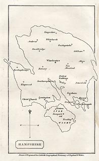
Our second anniversary this month is the 250th anniversary of the birth of William Cobbett, best known for his book Cobbett’s Rides, a topographical narrative of his travels around the south east of England still available in Penguin Classics form. The map I have chosen to illustrate this was published in A Geographical Dictionary of England and Wales, by Cobbett in 1832. The map shows an outline of Hampshire, in an almost unrecognisable shape - either a very strange projection or a bad map! The only features are the main towns.

Cobbett was born in Farnham, Surrey, and his grave can still be seen in the parish churchyard. At various times he was a sergeant-major in the British Army, a campaigning journalist, a political prisoner, an exile in America, the editor of journals, and the Radical MP for Oldham. In the 1820s he returned from political exile in America and undertook a series of rides through the countryside as the basis for a series of articles for publication in his own journal The Political Register. In 1830, he made a selection of the rides and published them in book form. http://www.geog.port.ac.uk/webmap/hantsmap/hantsmap/cobbett/cobbett1.htm         

Coming far more up to date for our third anniversary, this one actually happened 50 years ago when on 27 March 1963 the Chairman of British Railways Dr Richard Beeching issued a report calling for huge cuts to the UK's rail network.The map shows just how extensive our rail network used to be and even this one doesn’t show all the smaller branch lines that criss-crossed the country at the time. The initial report proposed the closure of over 6000 miles of railway and over 2300 stations. Some were reprieved, but over 1900 stations did close and the many ‘dismantled railway’ annotations that appear on OS maps bears testimony to just how many miles of track were decommissioned, with lots of the former lines now forming part of our long distance footpath or national cycle network routes.As one commentator noted, the name ‘Beeching’ quite often evokes a response normally associated with mass murderers and the report was deeply unpopular at the time. The Beeching closures failed in their attempt to eliminate BR's losses, achieving a saving of just £30 million, whilst overall losses were running in excess of £100 million per year. Beeching himself was unrepentant about his role in the closures: "I suppose I'll always be looked upon as the axe man, but it was surgery, not mad chopping." 


What do the following have in common?
  • Maps as music
  • Edwardian transport planning
  • Smells of Paris
  • Pacman
  • The map of 1000 cuts
  • Maps in the media
  • Word maps
They all featured in the Design Group’s excellent one-day workshop entitled ‘How maps inspire us’ at the Steer Davies Gleave offices on 14th March. It really was a fascinating day that took aspects of cartography that we are familiar with but looked at them from a totally different viewpoint.
We were treated to some very engaging talks from a range of speakers and it was noticeable that similar themes kept being picked out. The underlying theme was the sense of place and how we move from being in a ‘space’ to being in a ‘place’ by the things that we associate with it through a variety of senses.. We considered the associative elements of senses and what reminds us most of particular locations – think how often a smell can make you remember a particular place.

Looking ahead:
  • If you haven’t yet booked for the talk by Michael Palin at the RGS on 12th April it’s not too late to do so. Entitled ‘A life in Maps’, it promises to be a fascinating evening from one of our ‘National Treasures’. Book your ticket now
  • BCS will have a panel on the IMIA stand at the London Book Fair from 15th-17th  April, so if you are attending, please make sure that you come and visit us to see the pre-publication details of the BCS 50th anniversary book. Due for publication later this year the book celebrates 50 years of the Society by selecting a UK event and world event from each year and illustrating it with an appropriate map.
    Pre-publication price will be £12.50, so keep an eye on the website in the near future for details.  
Pete Jones MBE, CGeog, FRGS
26th March 2013

Blog List