Showing posts with label Rail. Show all posts

Monday, 2 September 2013

BCS President’s Report August 2013

As with July, another infamous criminal incident was making the headlines in the UK 50 years ago. The Great Train Robbery, originally referred to as the Cheddington Mail Van Raid took place on August 8th 1963. Just over £2.6M, equivalent to £41M today, was stolen. The plan was to intercept and rob the overnight Glasgow to London mail train. The train was halted by a red signal that had been rigged by the robbers just after passing through Leighton Buzzard. The driver, secondsman and the staff manning the high value coach were all overpowered. The train was then moved a few hundred yards down the line to Bridego Bridge, now renamed as Train Robbers bridge, where the money was offloaded into a lorry. The gang then made their way to their hideout at Leatherslade Farm, some 25 miles away. Although I was only 5 at the time, I can remember the events vaguely, primarily because the hideout was only about 10 miles from my family home in Bicester.
Most of the gang were captured, and some infamously subsequently escaped. Despite the fact that no firearms were used, the gang were given hefty sentences of 25-30 years.


On 28th August 1963 Martin Luther King delivered his ‘I have a dream’ address in Washington DC as part of the March on Washington. It was here that he established his reputation as one of the greatest orators in American history. Although toned down due to presidential pressure from John F Kennedy, the march made specific demands: an end to racial segregation in public schools; meaningful civil rights legislation, including a law prohibiting racial discrimination in employment; protection of civil rights workers from police brutality and a $2 minimum wage for all workers. Despite tensions, the march was a resounding success. More than 250,000 people of diverse ethnicities attended the event and at the time, it was the largest gathering of protesters in Washington, D.C.'s history.

King delivered a 17-minute speech, and in the speech's most famous passage—in which he departed from his prepared text, King said:
“I say to you today, my friends, so even though we face the difficulties of today and tomorrow, I still have a dream. It is a dream deeply rooted in the American dream. I have a dream that one day this nation will rise up and live out the true meaning of its creed: 'We hold these truths to be self-evident: that all men are created equal.'
I have a dream that one day on the red hills of Georgia the sons of former slaves and the sons of former slave owners will be able to sit down together at the table of brotherhood. I have a dream that one day even the state of Mississippi, a state sweltering with the heat of injustice, sweltering with the heat of oppression, will be transformed into an oasis of freedom and justice. I have a dream that my four little children will one day live in a nation where they will not be judged by the color of their skin but by the content of their character.
I have a dream today.
I have a dream that one day, down in Alabama, with its vicious racists, with its governor having his lips dripping with the words of interposition and nullification; one day right there in Alabama, little black boys and black girls will be able to join hands with little white boys and white girls as sisters and brothers.
I have a dream today.”

I have read and re-read this passage several times, trying to see if I could condense it for this bulletin, but in the end have decided to leave it as is. It is a powerful piece of oratory that 50 years later sounds strange to our ears in its choice of language and yet still resonates in a world where racial problems persist.
http://bsumaps.blogspot.co.uk/

The original image of the map, produced by Bell State University can be found on their website.

Map Design
One of the inevitable results of the ‘democratisation’ of cartography is that anyone can now easily access map making tools, but the lack of any training or instruction in some of the cartographic basics means that the results are often not pleasing on the eye, nor do they get across their intended message.
Beauty is in the eye of the beholder and a recent article in Cartographic Perspectives reminds us that it is not easy to measure good design, or to quote the article, 
“It is notoriously difficult to test the quality of a map’s design or beauty with any rigor, let alone establish some concrete, quantitative rules.”
Co-authored by BCS members Alex Kent and Ken Field, along with others, it is a very useful review of the topic and can be found on the Cartographic Perspectives website.


International Cartographic Conference, Dresden
The biennial ICC was held in Dresden at the end of August and was the prelude to the events of #maptember. This was the first one that I had been to and I was not sure what to expect. It is a major international gathering and the event attracted nearly 1200 delegates from 81 countries. Although I didn’t get round to meeting all of them, the BCS stand was quite popular and a number of people expressed interest in joining with one delegate even signing up on the day. Our international membership is quite strong and it was good to meet several of our overseas members including Roger Smith from New Zealand, who will be joining us at Symposium next week and must win the prize for travelling the furthest to be there! There was a strong UK presence at the Conference, many of whom were BCS members. The range of topics covered was impressive, reflecting the work of the many commissions of the ICA, several of which are chaired by UK delegates.
I thoroughly enjoyed the week and found it very educational and entertaining in equal parts. The conference was conducted almost exclusively in English and I never cease to be slightly embarrassed by the fact that we tend to be lazy when it comes to languages, although the variable standard of English at the Conference did lead to the occasional translation glitch. I think my favourite new term is “aggressive crossroads”. I think we’ve all been there!


Dresden is a very nice city, sensitively reconstructed after 1945 and proved to be a great host venue. It is fairly compact as a city making it easy to get around and with a direct flight from London City Airport, I can recommend it for a weekend city break. The local organising committee had done a fantastic job with the programme and the Conference itself ran extremely smoothly. I think the one thing to take away though is the tag line that the ICA President Georg Gartner used to conclude his welcoming speech at the start of the Conference, “It’s okay to be a cartographer”.

The next ICC Conference, in 2015, will be in Rio de Janeiro, sandwiched between the Football World Cup and the Olympics and the team from Rio were doing a great job of marketing it as a venue.


BCS Symposium 
As I sit writing this at 6:30 on a Saturday morning, the BCS Symposium is now only a couple of days away. Numbers attending are well up on previous years and for the first time I can remember we are now ‘full’. The programme looks particularly strong this year, especially with the heads of the five major UK mapping organisations presenting in the keynote session. Add to this the 50th anniversary celebrations, being attended by 11 former BCS Presidents, and the reason for the popularity this year is apparent.

I very much look forward to seeing all the delegates in Leicestershire.

Pete Jones MBE, CGeog, FRGS
31st August 2013


Saturday, 30 March 2013

BCS President’s Report March 2013

It’s always the way isn’t it, very few cartographic related anniversaries in February and then too many in March.
This month sees the 200th anniversary of the birth of Dr John Snow and for anyone who has attended a Better Mapping seminar, the first map will be very familiar to you as it is used by Giles Darkes as part of his talk illustrating how you can present statistical data using maps.
http://en.wikipedia.org/wiki/John_Snow_(physician)
Although he is better known as one of the founding fathers of modern epidemiology, Dr. John Snow produced this map of the area around the Broad Street pump to illustrate his hypothesis that cholera reproduced in the human body and was spread through contaminated water. This contradicted the prevailing theory that diseases were spread by "miasma" in the air. The September 1854 cholera outbreak was centred in the Soho district, close to Snow's house. Snow mapped the 13 public wells and all the known cholera deaths around Soho, and noted the spatial clustering of cases around one particular water pump. He examined water samples from various wells under a microscope, and confirmed the presence of an unknown bacterium in the Broad Street samples. Despite strong scepticism from the local authorities, he had the pump handle removed from the Broad Street pump and the outbreak quickly subsided. Snow subsequently published a map of the epidemic to support his theory.
In his talk Giles cleverly shows how the results can be ‘manipulated’ depending on how you categorise the data. If the area around the pump is partitioned in different ways, it can seriously skew the data and even suggest that the Broad Street pump is not necessarily the problem. A cautionary tale that is still valid today in reminding us that the aggregation and categorisation of data for portrayal graphically is vitally important to the message that we are trying to convey cartographically. Indeed, some anomalies are worth noting. Although the large workhouse just north of Broad Street housed over 500 paupers, it suffered very few cholera deaths because it had its own well (not shown on the map). The workers at the brewery one block east of the Broad Street pump could drink all the beer they wanted; the fermentation killed the cholera bacteria, and none of the brewery workers contracted cholera. Many of the deaths further away from the Broad Street pump were people who worked at the market on Broad Street and drank from that well.

For anyone wishing to find out more, there is an exhibition at the London School of Hygiene & Tropical Medicine, Keppel Street, London WC1E 7HT entitled ‘Cartographies of Life & Death – John Snow and Disease Mapping’. It opened on 15th March and runs until 17th April. 

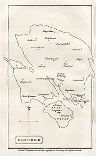
Our second anniversary this month is the 250th anniversary of the birth of William Cobbett, best known for his book Cobbett’s Rides, a topographical narrative of his travels around the south east of England still available in Penguin Classics form. The map I have chosen to illustrate this was published in A Geographical Dictionary of England and Wales, by Cobbett in 1832. The map shows an outline of Hampshire, in an almost unrecognisable shape - either a very strange projection or a bad map! The only features are the main towns.

Cobbett was born in Farnham, Surrey, and his grave can still be seen in the parish churchyard. At various times he was a sergeant-major in the British Army, a campaigning journalist, a political prisoner, an exile in America, the editor of journals, and the Radical MP for Oldham. In the 1820s he returned from political exile in America and undertook a series of rides through the countryside as the basis for a series of articles for publication in his own journal The Political Register. In 1830, he made a selection of the rides and published them in book form. http://www.geog.port.ac.uk/webmap/hantsmap/hantsmap/cobbett/cobbett1.htm         

Coming far more up to date for our third anniversary, this one actually happened 50 years ago when on 27 March 1963 the Chairman of British Railways Dr Richard Beeching issued a report calling for huge cuts to the UK's rail network.The map shows just how extensive our rail network used to be and even this one doesn’t show all the smaller branch lines that criss-crossed the country at the time. The initial report proposed the closure of over 6000 miles of railway and over 2300 stations. Some were reprieved, but over 1900 stations did close and the many ‘dismantled railway’ annotations that appear on OS maps bears testimony to just how many miles of track were decommissioned, with lots of the former lines now forming part of our long distance footpath or national cycle network routes.As one commentator noted, the name ‘Beeching’ quite often evokes a response normally associated with mass murderers and the report was deeply unpopular at the time. The Beeching closures failed in their attempt to eliminate BR's losses, achieving a saving of just £30 million, whilst overall losses were running in excess of £100 million per year. Beeching himself was unrepentant about his role in the closures: "I suppose I'll always be looked upon as the axe man, but it was surgery, not mad chopping." 


What do the following have in common?
  • Maps as music
  • Edwardian transport planning
  • Smells of Paris
  • Pacman
  • The map of 1000 cuts
  • Maps in the media
  • Word maps
They all featured in the Design Group’s excellent one-day workshop entitled ‘How maps inspire us’ at the Steer Davies Gleave offices on 14th March. It really was a fascinating day that took aspects of cartography that we are familiar with but looked at them from a totally different viewpoint.
We were treated to some very engaging talks from a range of speakers and it was noticeable that similar themes kept being picked out. The underlying theme was the sense of place and how we move from being in a ‘space’ to being in a ‘place’ by the things that we associate with it through a variety of senses.. We considered the associative elements of senses and what reminds us most of particular locations – think how often a smell can make you remember a particular place.

Looking ahead:
  • If you haven’t yet booked for the talk by Michael Palin at the RGS on 12th April it’s not too late to do so. Entitled ‘A life in Maps’, it promises to be a fascinating evening from one of our ‘National Treasures’. Book your ticket now
  • BCS will have a panel on the IMIA stand at the London Book Fair from 15th-17th  April, so if you are attending, please make sure that you come and visit us to see the pre-publication details of the BCS 50th anniversary book. Due for publication later this year the book celebrates 50 years of the Society by selecting a UK event and world event from each year and illustrating it with an appropriate map.
    Pre-publication price will be £12.50, so keep an eye on the website in the near future for details.  
Pete Jones MBE, CGeog, FRGS
26th March 2013

Blog List