Showing posts with label IMIA. Show all posts

Monday, 8 December 2014

BCS President's Bulletin November 2014


The BCS AGM was held at the RAF Club in London on 17th November and we reflected on another successful year for the Society. The Restless Earth schools' programme is proving to be as popular as ever, the Annual Symposium at Marwell ran jointly with IMIA was a great success, the BCS Awards were rejuvenated and proved to be a highlight of the Gala Dinner and our membership continues to grow, topping 700 at the end of the month. We are also in very good health financially and in response to a question at the AGM the Council will be looking at the reserves that we hold and will be determining ways of investing and using our assets to further develop the Society. We are aware that the BCS website needs updating and we will be offering online access to the Cartographic Journal in 2015, but if you have any specific proposals for how BCS funds could be employed then please get in touch.

The AGM was followed by a talk by BBC weather presenter Helen Willetts, who spoke about the ‘Changing Face of the Weather Map’. It was an excellent talk during which Helen covered a far greater timespan that I had anticipated, from ancient times right up to the modern day. It was a really entertaining and informative talk, sparked many questions from the audience and finally solved the mystery for me of the seven legged spider. Helen confessed afterwards that she hadn’t spoken in public for nearly eight years, but you couldn’t tell and she also confided to me that she had thoroughly enjoyed the evening.

Cartography in the News

You know you’re in trouble when the reigning monarch says that maps have been overtaken by satnavs, although if you read the article the headline is a bit misleading and that’s not what she actually said. What she actually said to one of the pupils who was finding co-ordinates on a map is that ‘Nowadays you probably have a satnav or something’. Yes, Ma'am, that something is a map. On the same page in the paper was a report on proposed changes to the driving test including 'asking candidates to follow directions on a satnav, as an alternative to following road signs'. I’m sorry but isn’t that just plain daft? I never navigate simply by following road signs, if I did getting from my home in Woking to say Leeds could be a bit of a challenge if I was relying solely on road signs as there aren’t too many in Woking that tell you where Leeds is. Edmund King president of the AA chimed in with 'Some still navigate with signs and maps'; useful concept ‘some’ just imprecise enough not to be able to disagree with it too vehemently.

Cartography on the Web

Just to remind us all that paper maps and satnavs are not necessarily mutually exclusive, a web article from HEMA maps, ‘down under’, shows how the two can be used successfully together. Rob Boegheim, the company’s managing director always starts his planning process with a paper map as he argues that its scope is still the best way to get the big picture when planning a trip. The progression from planning at home to discovering somewhere out in the bush, instantly transforms the basic paper map from planning tool into cheap insurance. Though the likelihood of technological failure is rare in most cases, a paper map is always an essential low cost backup that will pay dividends when called upon on the expedition.


Apparently brains and cauliflowers are similar in size and shape but if you have ever wondered what a map of your brain would look like, then we now have the answer. Nico Lambert’s rendering can be found at the link.


One of the guest speakers from our 50th Anniversary year, Jack Dangermond, has recently been quoted as saying that he wants top executives to think more like cartographers. Growth of GIS beyond its original boundaries is now making people realise the benefits to analysis and decision making if the geospatial element is fully considered. What is broadly termed as ‘location strategy’ is now a large factor in business allowing those who employ it to gain the competitive advantage.

I have been showcasing the ICA Map Carte webpage for the whole year (see below) and a new article by ICA President Georg Gartner, looks at cartography in the 21st century. One of his key points echoes the thoughts of HEMA maps in that there are significant differences in the way we use paper and digital outputs. Using a paper map gives you the broader picture so that you quickly develop a sense of place and can navigate an area comfortably relatively quickly, whereas the convenience of a small screen makes you concentrate on directions without developing that same sense of your surroundings.


The BCS Better Mapping seminars offered the concept that as well as literacy and numeracy, there was a third important skill of ‘graphicacy’, ie. the ability to read and understand graphical images, particularly maps. This point is taken up by Kenneth D. Madsen an assistant professor of geography at The Ohio State University at Newark. Whilst not advocating that we all learn by rote the locations of world countries and their capitals, he does argue that just as use of a calculator does not diminish the need to know basic maths and just as knowing the alphabet is a prerequisite for reading, so it is that knowledge of where to find places is useful for a greater understanding of geographic processes.


We have been bombarded over the years with news that cartography is a dying profession and there aren’t any cartographers any more, yet here we are still going very string. Well, now it would appear that GIS professionals are under threat. I subscribe to GISCafe and a recent article talked about a new breed of Geographer or is it Geospatial practitioner, geospatial developer or location specialist. The author Joseph Berry argues that in getting GIS more widely accepted and used amongst a non-specialist community, “We need individuals, who understand the challenges faced by the wider ‘non-GIS’ community. Who can bridge the divide, and communicate spatial solutions to a new set of problems, targeted at a new diverse group of users.” I think we call them cartographers don’t we?

ICA Map Carte

My first choice this month is really easy, Roy’s map of the Hounslow Heath baseline. Easy because his was the predecessor of the organisation that I now work for. Tracing its history back to 1747, Military Survey (as it was once known) mapped the UK and Ireland to a phenomenal degree given the technology at their disposal. You can still see the ends of the baseline marked by two upturned cannons, one in Ordnance Close and one at Heathrow airport, although the vast majority of people probably don’t know what they signify.

Another place on my bucket list is the Vatican, if only to see The Gallery of Maps, a 120m long gallery beautifully decorated with more than 40 works of art. Dating from the 1580s, their vibrant colours and remarkable detail are from an age when maps where starting to assume an important role in scientific discovery. Celebrating the central importance of Italy before it was a unified country, they were commissioned by Pope Gregory XIII, who wanted the Vatican to be a part of the scientific and cartographic revolution of the day.

My final choice this month is not necessarily the most obvious as it is neither beautiful nor particularly eye-catching. The Sachsenhausen Memorial and Museum Visitor Map is very powerful, presenting as the web site describes it 'a poignant and eerily clinical blend…a cold soulless landscape', something which perhaps a photograph could also invoke but something that this map achieves with stunning simplicity.

These and all the other maps that have been chosen throughout the year can be found at http://mapdesign.icaci.org/category/mapcarte/.

And Finally

Well, following last month’s toilet humour picture, for which I got no printable suggestions about what unconventional toilet paper could be, I am really struggling for something to finish this month’s offering. So what I will say is that December’s offering will come out on or about Christmas Eve and will contain exciting news about next year’s Symposium, so think of the next couple of weeks as a kind of BCS Advent Calendar, but without the chocolate.

Pete Jones MBE FBCart.S CGeog
8th December 2014

E-mail: peter.jones991@mod.uk
Twitter: @geomapnut

Tuesday, 4 March 2014

BCS President’s Monthly Bulletin February 2014


In January’s bulletin I set a question to identify the image below. Congratulations go to Stephen Low of Ordnance Survey, who correctly identified it as a gravity scar caused by the 2011 Great East Japan Earthquake as revealed by observations from ESA’s GOCE satellite. The effects of the magnitude 9.0 earthquake are clearly visible in GOCE’s gravity data, showing how the movement of rock and other material tens of kilometers below the surface causes small changes in the local gravity.


The Great East Japan Earthquake is still the subject of our Restless Earth Schools Programme, which continues to flourish. We have a total of 23 workshops arranged for this academic year and have already taken several bookings for next year, when we hope to be rolling out a GIS based version. This year, for the first time, BCS will have a stand at the Geographic Association Annual Conference and Exhibition at the University of Surrey from 14th to 16th April. As well as having a stand, we will also be running a Workshop at the Conference, so if you are attending make sure that you come along to Workshop 42 on the Wednesday morning. We anticipate that this will generate a lot of interest in Restless Earth, so we will be looking for more volunteers to help us run these in the future.


I set the Society the target of getting to 700 members last year and although we didn’t quite make it we have now, passing the 700 mark in early February. My next target is to get up to 750 by the end of 2014, so if you have friends or colleagues who are not yet members sign them up! This shows the Society to be in very good health with numbers continuing to climb across a good spread of the broader cartographic industry.


Do you know your ‘Stans’? Could you have identified it on the map if Kazakhstan hadn't been plastered right across it? The President of Kazakhstan is worried that we don’t and that his country is getting mixed up with others ‘inferior’ countries in the region. President Nursultan Nazarbayev is ready to do something about the problem and has suggested the idea of dropping the "stan" from Kazakhstan's name. The idea is to help the massive country stand out from its neighboring former Soviet republics in Central Asia. He suggested a name like "Kazakh Eli", which translates to The Land of the Kazakhs because that "would be more eye-catching for a foreigner studying the region's map."


Symposium 2014

Planning for this year’s Symposium is now well advanced and the booking form will soon appear on the BCS website, so keep an eye out for it. This year we are going to be at the Marwell Hotel and Conference Centre just south of Winchester and for the first time we will be holding it as a joint event with the International Map Industry Association (IMIA). The Symposium will begin on Tuesday with a joint session organised by the GIS and Design SIGs running a ‘Mapathon’ to produce a map in a day. We are hoping to attract lots of innovative new cartographers and it is the intention that the winning map at the end of the day will be used to support a UK charity. In the evening we also have a guest speaker from the RAF, explaining their role in using aerial photography to support the flood relief activities in Southern England. The full Symposium sessions follow on Wednesday and Thursday, including a mix of presentation and workshops and a visit to the Ordnance Survey offices in Southampton. And if you are a golfer then don’t miss the opportunity to play for The President’s Golden Ball Trophy. This year we will be at East Horton Golf Club, just a couple of miles from the Symposium venue, so even if you can’t make all of the Symposium, please join us on Friday for the sporting spectacular.


BCS Awards

 
The process for submitting your maps for the BCS awards is now live online at the BCS Website. There were some issues with the Awards process last year and we have totally revamped the process to ensure that we know what is going to be submitted and can track the submission of the entries ahead of the closing date at the end of April. So if you have produced something notable in the last 12 months please submit it for one or more of the Awards. Final judging will take place at Google’s London offices on 27th May and we are very grateful to Ed Parsons for agreeing to host us. The winners of the Awards will be announced at the Symposium Gala Dinner on Wednesday 25th June.


ICA Map Carte Selections for February


Did some of your ancestors go west and settle in the US? Then this map might be useful to help to find out where they may have ended up. This map achieves one of the key design considerations of being very clear and simple, whilst still conveying several pieces of information. The map shows the top 25 surnames in each state. They are sized by their magnitude in the same way as a proportional symbol to show quantitative information. Additionally, colour is used to denote the origin country so patterns of historic migration are easy to spot. All I can say is that there are an awful lot of Joneses, right across the continent! The zoomable version on the National Geographic website is the best way to view http://ngm.nationalgeographic.com/2011/02/geography/usa-surnames-interactive.


As well as location, population density is also implied through the general distribution and size of the names with the most densely packed and largest being located in urban areas and the more populated states.


The other selection that I particularly liked from February’s selection was the ‘Crossworld’ Map. A simple idea and a well crafted design with clues that broadly fit the locations of their position on the map.


To see the latest maps to be posted, visit the ICA MapCarte site at: http://mapdesign.icaci.org/category/mapcarte/


A-Z Maps – The Musical


I hope you caught this item on the BBC News website. The article was triggered by a new musical looking at the life of Phyllis Pearsall, called “The A-Z of Mrs P”. Phyllis was the founder of A-Z maps and the BCS gained some useful publicity as I had been contacted by the author, Jon Kelly, a few days previously to provide some background and was quoted in the article. In what is quite a well balanced article Jon does start by asking the question as to whether the paper map still has life in it, concluding that indeed it does.


And Finally….


One of the best cartographically related books that I have read is The Great Arc by John Keay, which tells the story of George Everest and his survey of India. If you haven’t read it, I would strongly recommend it and John is giving a talk on the subject at the National Army Museum on 27th March, full details of which are available at The National Army Museum website.


Pete Jones MBE, FBCartS, CGeog, FRGS

5th March 2014


Twitter: @geomapnut

Saturday, 30 March 2013

BCS President’s Report March 2013

It’s always the way isn’t it, very few cartographic related anniversaries in February and then too many in March.
This month sees the 200th anniversary of the birth of Dr John Snow and for anyone who has attended a Better Mapping seminar, the first map will be very familiar to you as it is used by Giles Darkes as part of his talk illustrating how you can present statistical data using maps.
http://en.wikipedia.org/wiki/John_Snow_(physician)
Although he is better known as one of the founding fathers of modern epidemiology, Dr. John Snow produced this map of the area around the Broad Street pump to illustrate his hypothesis that cholera reproduced in the human body and was spread through contaminated water. This contradicted the prevailing theory that diseases were spread by "miasma" in the air. The September 1854 cholera outbreak was centred in the Soho district, close to Snow's house. Snow mapped the 13 public wells and all the known cholera deaths around Soho, and noted the spatial clustering of cases around one particular water pump. He examined water samples from various wells under a microscope, and confirmed the presence of an unknown bacterium in the Broad Street samples. Despite strong scepticism from the local authorities, he had the pump handle removed from the Broad Street pump and the outbreak quickly subsided. Snow subsequently published a map of the epidemic to support his theory.
In his talk Giles cleverly shows how the results can be ‘manipulated’ depending on how you categorise the data. If the area around the pump is partitioned in different ways, it can seriously skew the data and even suggest that the Broad Street pump is not necessarily the problem. A cautionary tale that is still valid today in reminding us that the aggregation and categorisation of data for portrayal graphically is vitally important to the message that we are trying to convey cartographically. Indeed, some anomalies are worth noting. Although the large workhouse just north of Broad Street housed over 500 paupers, it suffered very few cholera deaths because it had its own well (not shown on the map). The workers at the brewery one block east of the Broad Street pump could drink all the beer they wanted; the fermentation killed the cholera bacteria, and none of the brewery workers contracted cholera. Many of the deaths further away from the Broad Street pump were people who worked at the market on Broad Street and drank from that well.

For anyone wishing to find out more, there is an exhibition at the London School of Hygiene & Tropical Medicine, Keppel Street, London WC1E 7HT entitled ‘Cartographies of Life & Death – John Snow and Disease Mapping’. It opened on 15th March and runs until 17th April. 

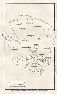
Our second anniversary this month is the 250th anniversary of the birth of William Cobbett, best known for his book Cobbett’s Rides, a topographical narrative of his travels around the south east of England still available in Penguin Classics form. The map I have chosen to illustrate this was published in A Geographical Dictionary of England and Wales, by Cobbett in 1832. The map shows an outline of Hampshire, in an almost unrecognisable shape - either a very strange projection or a bad map! The only features are the main towns.

Cobbett was born in Farnham, Surrey, and his grave can still be seen in the parish churchyard. At various times he was a sergeant-major in the British Army, a campaigning journalist, a political prisoner, an exile in America, the editor of journals, and the Radical MP for Oldham. In the 1820s he returned from political exile in America and undertook a series of rides through the countryside as the basis for a series of articles for publication in his own journal The Political Register. In 1830, he made a selection of the rides and published them in book form. http://www.geog.port.ac.uk/webmap/hantsmap/hantsmap/cobbett/cobbett1.htm         

Coming far more up to date for our third anniversary, this one actually happened 50 years ago when on 27 March 1963 the Chairman of British Railways Dr Richard Beeching issued a report calling for huge cuts to the UK's rail network.The map shows just how extensive our rail network used to be and even this one doesn’t show all the smaller branch lines that criss-crossed the country at the time. The initial report proposed the closure of over 6000 miles of railway and over 2300 stations. Some were reprieved, but over 1900 stations did close and the many ‘dismantled railway’ annotations that appear on OS maps bears testimony to just how many miles of track were decommissioned, with lots of the former lines now forming part of our long distance footpath or national cycle network routes.As one commentator noted, the name ‘Beeching’ quite often evokes a response normally associated with mass murderers and the report was deeply unpopular at the time. The Beeching closures failed in their attempt to eliminate BR's losses, achieving a saving of just £30 million, whilst overall losses were running in excess of £100 million per year. Beeching himself was unrepentant about his role in the closures: "I suppose I'll always be looked upon as the axe man, but it was surgery, not mad chopping." 


What do the following have in common?
  • Maps as music
  • Edwardian transport planning
  • Smells of Paris
  • Pacman
  • The map of 1000 cuts
  • Maps in the media
  • Word maps
They all featured in the Design Group’s excellent one-day workshop entitled ‘How maps inspire us’ at the Steer Davies Gleave offices on 14th March. It really was a fascinating day that took aspects of cartography that we are familiar with but looked at them from a totally different viewpoint.
We were treated to some very engaging talks from a range of speakers and it was noticeable that similar themes kept being picked out. The underlying theme was the sense of place and how we move from being in a ‘space’ to being in a ‘place’ by the things that we associate with it through a variety of senses.. We considered the associative elements of senses and what reminds us most of particular locations – think how often a smell can make you remember a particular place.

Looking ahead:
  • If you haven’t yet booked for the talk by Michael Palin at the RGS on 12th April it’s not too late to do so. Entitled ‘A life in Maps’, it promises to be a fascinating evening from one of our ‘National Treasures’. Book your ticket now
  • BCS will have a panel on the IMIA stand at the London Book Fair from 15th-17th  April, so if you are attending, please make sure that you come and visit us to see the pre-publication details of the BCS 50th anniversary book. Due for publication later this year the book celebrates 50 years of the Society by selecting a UK event and world event from each year and illustrating it with an appropriate map.
    Pre-publication price will be £12.50, so keep an eye on the website in the near future for details.  
Pete Jones MBE, CGeog, FRGS
26th March 2013

Thursday, 3 January 2013

BCS President’s Report October 2012


Looking back October has been a quiet month for all sorts of reasons. A number of our members attended the Frankfurt Book Fair and I’m looking forward to reading Alan Grimwade’s report on the event in the next edition of Maplines. The IMIA, International Map Industry Association, was IMTA so ‘Trade’ has been changed to ‘Industry’, had a stand there and a number of our members were involved.

Our Restless Earth Workshop at Sandhurst was first delayed 2 days and then cancelled by the school which is a great pity as our resources are limited. Going along with the cancellation theme we had to cancel the GIS SIG because of a lack of attendees! The lesson learnt here is that, in future, we need to ensure that a GIS SIG takes place alongside another event. However, the GIS SIG in October 2013 should be packed, there’s a clue below.

Peter Jones, DGC, and
new BCS President
On a cheerful note the AGM at the RAF Club on 31st went as planned. I’m pleased to say that the Society continues to ‘buck the trend’ as our membership continues to grow and our finances are stable showing a small surplus over the last financial year. After the AGM I duly handed over the chain of office to Peter Jones from DGC our new President. After the reception we had an excellent presentation from Steven Feldman during which he described the development of web mapping over the years.  After another short break we had dinner which appropriately enough was held in the President’s room.

November starts with a Council meeting which is followed by 3 GEOData events in Glasgow, Bristol and Belfast where we have a BCS stand and a Restless Earth Workshop at Altincham Boys Grammar School.

Our plans for 2013, our 50th Anniversary, are beginning to firm up and I’m sure you’ll be pleased to learn that Michael Palin and Jack Dangermond, President of Esri Inc, have both agreed to take part in the celebrations. Some 6 months ago we invited the SoC to join us at our 2013 Symposium in Leicester during September but I’m sorry to say that they have declined our offer. I remember the joint event we held in Reading some years ago and what a great success that was. I’d like to think there might be a change of heart.

So this is my last monthly email as your President. I hope they have helped to keep you up-to-date with the Society’s activities and events. It has been a great pleasure and privilege to be your President. I firmly believe that the Society has a great future promoting good cartography to those thousands of map makers many of whom might well benefit from a bit of advice. Thank you all for your help and support.  Finally, my Very Best Wishes to Peter Jones, our new President, who already has persuaded me to become chair of the Programme Committee.

Best Wishes

Peter Jolly
Past President

Blog List