Showing posts with label Schematic. Show all posts

Thursday, 3 January 2013

BCS President’s Report December 2012


A Very Merry Cristmas and a Happy New Year

An early Christmas message as Roger our Administrative Officer is taking a well earned rest from Membership renewals for a couple of weeks.

Yes, it is a deliberate mistake in the title, I have dropped the ‘h’ from Christmas. Why? Well there is much debate about the correct use of English and dropped aitches have been around for many a year, but usually at the beginning of words. The example I found recently was more subtle and led me to wonder if a new word had been coined. Hopefully you will have spotted the error in the extract (left) from The Times list of ideal Christmas presents ‘For Him’. Firstly I would take issue with a book about maps being in the ‘For Him’ section and secondly just what is ‘cartograpy’? Is it a combination of maps and wine, which may be of interest to many, is it the mapping of wine regions? Either way, perhaps it’s a good excuse to raise a glass or two during the festive period as ‘map books’ are becoming increasingly popular and mainstream, showing that there is a continued and growing interest in the subject.

Maps produced by Mary Spence
On the subject of books, those of you who have bought, or may receive as a Christmas present, ‘Brazil’, the book that accompanies Michael Palin’s recent TV series, will be interested to know that the maps in the book were produced by Mary Spence, past BCS President and still very much involved with Programme Committee. We are very pleased to announce that Mary has persuaded Michael to give a talk to BCS members next year as part of our 50th Anniversary celebrations. The talk will take place at the Royal Geographical Society in London on Friday 12th April. Full details will be sent out in the New Year, but definitely a date for your diary.


The big event this month was the London Mapping Festival Mapping Showcase held at Lord’s Cricket Ground on 6th December. This was the culmination of the Festival and was a huge success. BCS had a stand at the Showcase and we were kept busy all day speaking to existing members and encouraging new members to join. We had taken along some examples of the Restless Earth resources and maps produced by Year 10 students, which generated a lot of interest.

The London Mapping Festival was the brainchild of the GeoInformation Group and I would like to offer them my congratulations on an excellent initiative. The 18 month-long festival encompassed a wide variety of events and I hope that you managed to get along to some of them? The Mapping Showcase was notable for the wide range of exhibitors, from the entire spectrum of the cartographic industry and the extensive range of attendees from the GIS professional to the self confessed ‘map nut’. There was also a good range of presentations throughout the day on some very thought provoking topics that are very relevant to the cartographic community at the moment. With over 500 registered delegates it showed that the industry is in very good health at the moment and The BCS needs to capitalise on this by further increasing our membership base and ensuring that we fully meet the needs of our members, no matter which sector of the industry they are working in.

50th Anniversary Events
Following on from the London Mapping Festival’s example, for our 50th anniversary year in 2013, we are aiming to hold events on a regular basis around the country to offer the chance to attend a BCS event to as many members as possible. A provisional programme has been put together by the Programme Committee, but if there is an area or event that you would like to organise, please do get in touch with us as we want the year to be as inclusive as possible. January sees the BCS having a stand at DGI Global from 22nd to 24th. This is aimed at the Defence community and is attended by delegates, as the name suggests, from a global audience. BCS has had a stand at previous events when it was DGI Europe and we have generated a lot of interest in the Society.

On 24th January the UKGEOforum 2013 Annual Lecture will be held at the Royal Institution of Chartered Surveyors in London. This year’s lecturer is Mark Ovenden and his lecture is entitled “How Beck's diagram re-mapped the modern world”. Early booking for this event is recommended as places are limited. Roger sent out full details of the lecture on 19th November. Mark was a presenter at the Symposium this year, where he delivered a workshop entitled ‘Making a practical transit map’ and from the delegate feedback it was very well received.

For those of you with children, or if you are just a big kid yourself, then you may be interested in keeping up with Santa’s progress on Christmas Eve by following him on the NORAD Santa Tracker website - http://www.noradsanta.org/. North American Aerospace Defense Command (NORAD) is a joint organization of Canada and the United States that provides aerospace warning, air sovereignty, and defence for the two countries and whilst Santa is not seen as a ‘threat’ he does get tracked every year. It’s good fun and is a useful persuasive measure to get children to bed, although given that they are usually so excited there is no guarantee of sleep I’m afraid. So log on and follow his progress across the world map and ensure that you are in bed before he arrives to deliver your presents!


Which, I think, just leaves me to wish you a Very Merry Christmas and a Happy New Year. Let’s hope that it is a peaceful and quiet time that we can enjoy with family and friends.

Best Wishes

Friday, 25 November 2011

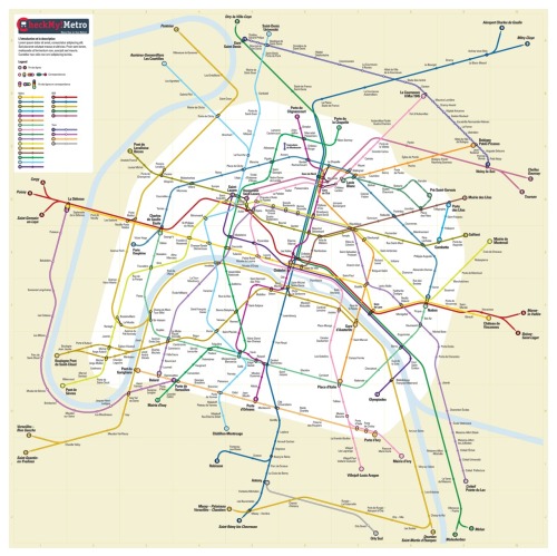
Guest Blog - Paris Metro Map design

In the light of the discussions at the recent GIS SIG seminar, I thought BCS members may be interested in a competition to create a new Paris Metro map. 
I was invited to take part and have been selected as one of the finalists. The overall winner will be selected by popular vote (via Facebook) but I’m not asking for mine to be favoured, I just thought the competition needs as wide an audience as possible. I have the impression it is the sort of thing that may interest the members of the BCS and ICA especially as the last meeting was in Paris.

I would be interested to hear what you and the other members think of the entries:
See the facebook page

And here is the link to the press release: http://checkmylabs.tumblr.com/

Mark,
Mark Noad Design

Wednesday, 21 September 2011

BCS President’s Report September 2011

As is usual September began with a flourish. 


The UKCC met in York on Monday 5 September. The main topics raised were: first, the ICC in Paris - David Forrest gave a report on the work of the General Assembly and all had an opportunity to comment on the organisation of the event.  The UK won 2 awards, Best Thematic Map – Ken Field and Best Educational Cartographic Product (Digital) – HarperCollins. Second, there were reports from Commission chairs and vice-chairs and lastly, there was an initial discussion on the UKCC Review. A draft paper has been circulated to Council for comment by 30 September prior to a second draft. In future, details of the UKCC’s work and ICA events, commission reports etc will be posted on the BCS website for all to see. Work on this has already begun.


The following day the Council also met at the same venue. This was a routine meeting covering membership and finance, the UKCC Review, Committee and SIG reports. There was also a discussion about having a lunchtime event for Fellows in the spring next year and that discussion is on-going.
On Wednesday the Map Curator’s Group met and I understand had a very successful meeting. My thanks go to Ann Sutherland, April Carlucci, Anne Taylor and Paula Williams for running and organising the event.

We, BCS, have a stand at the AGI Geocommunity ’11 conference in Nottingham 21-22 September. This will be another opportunity to encourage attendees to join BCS. Over the last 12 months membership has increased significantly, up to 657 compared with 615 at the same time last year and, as a result, in part, the financial position of the Society has strengthened. As well as new members from the UK we have new members from Chile, Nigeria, USA and Australia.

FREE attendance for Year 10s
On Monday, 26 September, the BCS team led by Peter Jones, will be presenting the ‘Restless Earth’ package to the year 10 students at Lampton School, Hounslow, in the morning and about 70 students from other schools in the area in the afternoon. It should be a great day.

The following day the UK GEOForum meets at Canary Wharf to discuss matters of mutual interest to the 15 member societies. These meetings are always useful as we can discuss and debate the common concerns.

Next, the cut-off date for submission of articles for the Winter edition of Maplines is 13 October so please make sure that if you have a contribution to make that Lynda Bailey and her team get the information and photographs etc on time. I should also tell you that Martin Lubikowski has taken over as the chairman of the Publications Committee. Our thanks go to Peter Collier for the work he did as Martin’s predecessor.

November 1 is an important date for your diary. There will be a curry lunch in the RAF Club followed by the GIS SIG. The SIG is open to everyone and is entitled, ‘GIS and Schematic Mapping’. These maps are particularly popular in the transport industry and at the end of the sessions we should know more about their uses, advantages and limitations so please do come and join in. There will also be a report of the recent ICC in Paris by David Forrest which again should be of interest to all. Then it will be time for the AGM at which the election results for Council for the coming year will be announced. Roger Hore will be sending out all the necessary paper work shortly. All booking details are on the BCS website.

So, a busy time for all but very worthwhile.
Best Wishes
Peter Jolly
BCS President

Blog List