Saturday 30 March 2013

BCS President’s Report March 2013

It’s always the way isn’t it, very few cartographic related anniversaries in February and then too many in March.
This month sees the 200th anniversary of the birth of Dr John Snow and for anyone who has attended a Better Mapping seminar, the first map will be very familiar to you as it is used by Giles Darkes as part of his talk illustrating how you can present statistical data using maps.
http://en.wikipedia.org/wiki/John_Snow_(physician)
Although he is better known as one of the founding fathers of modern epidemiology, Dr. John Snow produced this map of the area around the Broad Street pump to illustrate his hypothesis that cholera reproduced in the human body and was spread through contaminated water. This contradicted the prevailing theory that diseases were spread by "miasma" in the air. The September 1854 cholera outbreak was centred in the Soho district, close to Snow's house. Snow mapped the 13 public wells and all the known cholera deaths around Soho, and noted the spatial clustering of cases around one particular water pump. He examined water samples from various wells under a microscope, and confirmed the presence of an unknown bacterium in the Broad Street samples. Despite strong scepticism from the local authorities, he had the pump handle removed from the Broad Street pump and the outbreak quickly subsided. Snow subsequently published a map of the epidemic to support his theory.
In his talk Giles cleverly shows how the results can be ‘manipulated’ depending on how you categorise the data. If the area around the pump is partitioned in different ways, it can seriously skew the data and even suggest that the Broad Street pump is not necessarily the problem. A cautionary tale that is still valid today in reminding us that the aggregation and categorisation of data for portrayal graphically is vitally important to the message that we are trying to convey cartographically. Indeed, some anomalies are worth noting. Although the large workhouse just north of Broad Street housed over 500 paupers, it suffered very few cholera deaths because it had its own well (not shown on the map). The workers at the brewery one block east of the Broad Street pump could drink all the beer they wanted; the fermentation killed the cholera bacteria, and none of the brewery workers contracted cholera. Many of the deaths further away from the Broad Street pump were people who worked at the market on Broad Street and drank from that well.

For anyone wishing to find out more, there is an exhibition at the London School of Hygiene & Tropical Medicine, Keppel Street, London WC1E 7HT entitled ‘Cartographies of Life & Death – John Snow and Disease Mapping’. It opened on 15th March and runs until 17th April. 

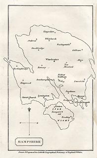
Our second anniversary this month is the 250th anniversary of the birth of William Cobbett, best known for his book Cobbett’s Rides, a topographical narrative of his travels around the south east of England still available in Penguin Classics form. The map I have chosen to illustrate this was published in A Geographical Dictionary of England and Wales, by Cobbett in 1832. The map shows an outline of Hampshire, in an almost unrecognisable shape - either a very strange projection or a bad map! The only features are the main towns.

Cobbett was born in Farnham, Surrey, and his grave can still be seen in the parish churchyard. At various times he was a sergeant-major in the British Army, a campaigning journalist, a political prisoner, an exile in America, the editor of journals, and the Radical MP for Oldham. In the 1820s he returned from political exile in America and undertook a series of rides through the countryside as the basis for a series of articles for publication in his own journal The Political Register. In 1830, he made a selection of the rides and published them in book form. http://www.geog.port.ac.uk/webmap/hantsmap/hantsmap/cobbett/cobbett1.htm         

Coming far more up to date for our third anniversary, this one actually happened 50 years ago when on 27 March 1963 the Chairman of British Railways Dr Richard Beeching issued a report calling for huge cuts to the UK's rail network.The map shows just how extensive our rail network used to be and even this one doesn’t show all the smaller branch lines that criss-crossed the country at the time. The initial report proposed the closure of over 6000 miles of railway and over 2300 stations. Some were reprieved, but over 1900 stations did close and the many ‘dismantled railway’ annotations that appear on OS maps bears testimony to just how many miles of track were decommissioned, with lots of the former lines now forming part of our long distance footpath or national cycle network routes.As one commentator noted, the name ‘Beeching’ quite often evokes a response normally associated with mass murderers and the report was deeply unpopular at the time. The Beeching closures failed in their attempt to eliminate BR's losses, achieving a saving of just £30 million, whilst overall losses were running in excess of £100 million per year. Beeching himself was unrepentant about his role in the closures: "I suppose I'll always be looked upon as the axe man, but it was surgery, not mad chopping." 


What do the following have in common?
  • Maps as music
  • Edwardian transport planning
  • Smells of Paris
  • Pacman
  • The map of 1000 cuts
  • Maps in the media
  • Word maps
They all featured in the Design Group’s excellent one-day workshop entitled ‘How maps inspire us’ at the Steer Davies Gleave offices on 14th March. It really was a fascinating day that took aspects of cartography that we are familiar with but looked at them from a totally different viewpoint.
We were treated to some very engaging talks from a range of speakers and it was noticeable that similar themes kept being picked out. The underlying theme was the sense of place and how we move from being in a ‘space’ to being in a ‘place’ by the things that we associate with it through a variety of senses.. We considered the associative elements of senses and what reminds us most of particular locations – think how often a smell can make you remember a particular place.

Looking ahead:
  • If you haven’t yet booked for the talk by Michael Palin at the RGS on 12th April it’s not too late to do so. Entitled ‘A life in Maps’, it promises to be a fascinating evening from one of our ‘National Treasures’. Book your ticket now
  • BCS will have a panel on the IMIA stand at the London Book Fair from 15th-17th  April, so if you are attending, please make sure that you come and visit us to see the pre-publication details of the BCS 50th anniversary book. Due for publication later this year the book celebrates 50 years of the Society by selecting a UK event and world event from each year and illustrating it with an appropriate map.
    Pre-publication price will be £12.50, so keep an eye on the website in the near future for details.  
Pete Jones MBE, CGeog, FRGS
26th March 2013

Wednesday 6 March 2013

BCS President’s Report February 2013


A quiet month for BCS activities as February often is. It feels like you’re coming out of winter, but it’s not really spring yet, it’s an in between time that can be bracingly nice or very damp and grey. No prizes for correctly identifying which we are enjoying at the moment. We have run two Restless Earthworkshops, one in Chipping Norton and one in Hackney and their popularity is as high as ever. We have another 3 confirmed for this academic year and several possible venues still to be confirmed.

Coming up in March, we have the Design Group Special Interest Group event on 14th March at the Steer Davies Gleave offices in London. The title is ‘How Maps Inspire Us’ and the SIG have lined up some excellent speakers from disciplines outside traditional cartography who will present on why they find maps inspirational.

Planning for the Annual Symposium in September is well advanced and the draft programme should be out soon. We have papers from a wide range of contributors, including the Heads of the major UK Mapping Agencies. This Symposium will also include the biennial Helen Wallis Memorial Lecture, this year being delivered by Nick Millea of the Bodleian Library.


Two months into the 50th anniversary and I’ve hit the buffers, metaphorically. A quiet month for anniversaries, I’ve had to opt for something that actually had its centenary last year, with a rather disquieting footnote in 2013. It was on 10th February 1913, that the body of Robert Falcon Scott was found, along with Edward Wilson and Henry Bowers, by the relief party sent to search for Scott’s ill fated expedition. The centenary was commemorated with a special map produced by Cheri Hunston MA artist, author and illustrator based in South Devon as part of the International Scott Centenary Expedition. Copies can still be purchased via her website. Cheri kindly gave permission for the image of the map to feature in this Bulletin. There is also a blog thatCheri set up which details all the research and the day to day development of the map.

Staying with the theme of icy wastes, the winter of 1963 was a particularly cold one in the UK, especially in January and February. This was in the days before undersoil heating for football pitches and the FA Cup was particularly badly hit by the weather. The fifth round was originally scheduled for Saturday 16th February, but the delays to the matches in the third and fourth rounds prevented the fifth round ties from being played until much later.

The freezing conditions hit the country just before Christmas 1962 and for the next three months the list of postponements indicate just how bad things were. Only three FA Cup third round ties were played on the scheduled date of January 5th, with the last tie in that round being played on March 11th. The Lincoln v Coventry tie was postponed 15 times and fourteen of the other ties suffered ten or more postponements.

http://www.shipwrecklog.com/log/2013/01/uss-guardian-update/uss-guardian-4/This happened in January, but a bit too late to make my last bulletin. The latest in a series of what the original article referred to as a “super-duper-epic-digital-mapping fail”. The USS Guardian ran aground on a reef in the Philippine Sea. The Tubbataha Reef is an environmentally sensitive natural park, and the Guardian was navigating through the area without the necessary clearance. When Philippine officials informed the Guardian that it had entered a restricted area, and would have to be boarded and inspected, the ship replied: “Take it to the U.S. Embassy.” And then it hit the reef and got stuck! No one was injured and no fuel oil leaked, but the damage to the reef may be extensive and the Navy has decided to scrap the $277 million ship, cutting it into three parts to remove it from the reef without further damage.

So what's this got to do with cartography?

A few days after the incident, the Navy revealed that the digital maps the Guardian used to navigate misplaced the reef by about eight nautical miles. The Navy has since advised other ships to compare electronic charts to paper ones before following directions. The full article can be found at the link ReadWrite Article.

A rare double, as 2013 is the 540th anniversary of the birth and the 470th anniversary of the death of Nicolaus Copernicus. He was the first to conclusively prove that the Earth was not the fixed centre of the universe, nor did the sun and the stars move around us as Ptolemy had argued more than a millennium earlier.


And finally, what the BBC referred to as “One of the most important space launches of the year” took place on 11th  February. Landsat-8 was launched from Vandenburg Air Force Base. The satellite being deployed by this mission will maintain the longest continuous image record of the Earth's surface as viewed from space. Landsat-1 was launched in 1972 and whilst we may now be getting used to seeing high resolution satellite imagery, the 15m to 100m wavelength of the Landsat missions provides an invaluable tool for a wide variety of research activities including monitoring the health of crops, the status of volcanoes, measuring the growth of cities and the extent of glaciers. If you think you don’t really access much Landsat imagery think again, as one of its best known uses is on Google Earth and Google Maps as background information.


Footnote – nothing at all to do with cartography, but it made me chuckle and I thought I’d share it with you to cheer up a dull February.

BCS President’s Report January 2013


31st January 2013

Very Best Wishes for a Happy New Year as we embark on 12 months of celebration for the 50th Anniversary of The British Cartographic Society. The Programme Committee have put together an excellent variety of events to celebrate our 50th year and I do hope that you will be able to make it to at least one of our events this year to help us celebrate the occasion with as many members as possible. We are already advertising our ‘Evening with Michael Palin’ on the website. He will be talking to us on 12th April at the RGS in London, so get online and book your tickets as it is bound to be a popular event.


On the subject of our 50th Anniversary, I thought it might be interesting to do a monthly check on who else is celebrating this month. The Metropolitan Underground Railway opened in 1863, so beats us by 100 years. The first services couldn’t have been very comfortable experiences with the soot and smoke, but having said that travelling on the underground last week during the rush hour wasn’t exactly fun. The delineation on the left is the first line, reproduced faithfully and is definitely pre-Beck. Those of you who attended the Annual UKGeoforum lecture will have heard Mark Ovenden’s excellent talk on underground maps, a topic which has certainly been to the fore recently. Mark is a prolific author and his latest book “London Underground by Design”, was published recently and is a ‘must’ for those interested in cartographic design.

The Flying Scotsman’s last scheduled run took place in 1963. As the map illustrates, it operated on the East Coast Route and could do the run from London to Edinburgh in just under 7 and a half hours, compared to today’s quickest time of 4 hours 19 minutes. With all the current debate on the HS2 link, the desire to get everywhere as quickly as possible seems to occupy the mind as much as ever. A lot of maps have appeared in the media this week, with a good proportion of the coverage speculating on the ‘kink’ in the line in Cheshire, with the more scurrilous suggesting that the change in alignment has something to do with not wishing to affect a certain part of the Chancellor’s constituency.

There has also been a lot of speculation in the press about whether there will be a referendum on our relationship with Europe and whether it will be a ‘Yes’ or ‘No’ question. Well, back in 1963, President de Gaulle said “Non” to Britain’s membership of the European Economic Union. Enlargement has been a principal feature of the Union's political landscape. The EU's predecessors were founded by the "Inner Six", those countries willing to forge ahead with the Community whilst others remained sceptical. The French President feared British membership and vetoed its application. It was only after de Gaulle left office and a 12-hour talks session by British Prime Minister Edward Heath and French President George Pompidou took place that Britain's third application succeeded in 1970.

WASHINGTON--An alarming new study released Tuesday by the Department of Education found that nearly 70 percent of Americans are incapable of pointing out a map when presented by researchers with a map. "Not only did a majority of people just stare blankly ahead, but nearly half pointed to nearby desk lamps in their attempts to guess correctly," said Secretary of Education Arne Duncan, who called the findings endemic of the nation's failing school system. "In fact, 14 percent of all Americans claimed they had never 'even heard of no map,' and asked if being prompted to locate one was some kind of trick question." According to Duncan, the Department of Education has suspended all further studies and will instead be spending the next six months just screaming into a pillow.”

Yes, it’s a real quote, but No, it’s not serious. It was taken from “The Onion” a satirical publication in the US, forwarded to me by courtesy of LISMaps. And yet, I suspect that there may be an element of truth in it as much in the UK as in the US. Our schools initiative has clearly shown that secondary students do not get a lot of exposure to maps through the curriculum, but that when they do they are capable of producing some quality output in response to the task we set them. We are always looking for helpers at these events, so if you would like to help, check out the BCS website and get in touch, it would be great to get more BCS members involved in our outreach activities.

Whilst I will not be making a habit of welcoming all of our new members – hopefully it would be too much of a task – I would like to give a special mention to our first School. Altrincham Grammar School for Boys, is one of the first schools that we went to with the Restless Earth Workshop. We returned again this academic year and already have a booking to return again in 13/14. We are very pleased that they have joined us as a Small Corporate Member and hope they will be the first of many.

Late breaking news – the BCS has been asked to provide a speaker on next week’s Today programme on Radio 4. We don’t know which day yet, so keep an eye on the website for the latest news.


Guest Blog - Map Examples requested for ICC Dresden from BCS Members


International Map Exhibition,  ICC 2013, Dresden, August 26th- 30th.
The International Cartographic Association (ICA) meets for its 26th International Cartographic Conference in Dresden in August (see www.ICC2013.org). As part of the conference there will be an exhibition of cartographic products from around the world. For the UK contribution to the exhibition you are invited to you to submit examples of any cartographic products prepared or published by you since March 2011. Please provide two copies of each item wherever possible; one copy will be displayed in the International Map Exhibition in Dresden. The other copy will be exhibited at a future BCS event and will be added to the BCS collection held in the National Library of Scotland. 

Entries are invited in 5 categories: printed maps; atlases; digital products; educational cartographic products; and other cartographic products (including globes, tactile maps, etc).


For ALL entries, you must supply an image of the product (jpeg or tiff) with a minimum resolution of 300dpi. For maps this should be the full image; for atlases this should be the cover; for digital products it should be a screenshot; for education products it should be appropriate, as above; for other products it should be a picture. Details of each entry must be completed under the appropriate category on an excel spreadsheet which is available from the BCS website: www.cartography.org.uk . The image files and spreadsheet should be sent as an e-mail attachment to:- david.forrest@glasgow.ac.uk no later than Monday 25th March 2013.

Two copies of each map, atlas, globe, or other product (CD/DVD/etc.), should be sent to me at the address below to arrive no later than Wednesday 27th March 2013. Please enclose a printed copy of the spreadsheet with your entry. For websites, please enter the URL at the start of the abstract. If the number of submissions exceeds our allocated display space the UKCC will select the most representative entries from those submitted.

By submitting an entry the product, and the use of the winning products in analogue or digital form, is granted to ICA for further promotional use. After the ICC2013 display of the analogue and digital winning entries remain available to ICA for further use and archiving.

If you have any questions regarding any aspects of this invitation please contact me by e-mail or on 0141 330 5401 Meanwhile, I look forward to receiving your contributions.

David Forrest PhD, FBCart.S
UK Committee for Cartography

David Forrest, PhD, FBCart.S
School of Geographical & Earth Sciences
Gilbert Scott Building
University of Glasgow
Glasgow G12 8QQ

Tel: 0141 330 5401

Email: david.forrest@glasgow.ac.uk


Blog List